Florida collects no state income tax. Property taxes, therefore, are the only means to fund infrastructure development. So to get property tax revenues up the city is permitting shoreline property developers to build 47 new condominiums in Miami Beach. And people are buying.

Consider what climate scientists are predicting for South Florida as sea levels continue to rise from a warming ocean and melting polar glaciers and sea ice. One climatologist, David Zierden, at Florida State University, recently stated “When you consider current hurricane threats, and the sea level rise that could erode these properties….Common sense says no, you shouldn’t do it.”
The project Miami Beach has undertaken includes 80 storm pumps that can pump sea water back into Biscayne Bay at a rate of 53,000 liters (14,000 gallons) per minute. This may help to mitigate the current state of frequent flooding that occurs at high tide but will it withstand sea levels that rise by a mean average of 0.4 meters (1.3 feet) in the next 85 years? And that 0.4 meters rise is a low-end estimate representing a global mean. Recent research done at Florida State University suggests a much more dire predicament, a local sea level rise of 81 centimeters (32 inches).
Of course the numbers above only cover a calm sea. Storm surges both in winter and during hurricane season will actively erode the Miami Beach area far beyond the impacts of rising sea levels. A single storm surge of 50 centimeters (19 inches) today is close to half the average elevation of the City which stands at 1.2 meters (4 feet). Now imagine a higher sea level combined with a storm surge and the entire City could be inundated.
Today Miami Beach loses its beaches with great regularity after Atlantic Ocean storms. Sand is imported to keep up the appearance of continuity. But that is far from the case.
With the City celebrating its 100th birthday the question is, will it be around for the next one hundred?

New York recognized not just waterfront property would be impacted by climate change and weather events. Flooding could immobilize 700 miles of subway, impact the 90,000 miles of underground power cables, compromise 14 wastewater treatment plants, and potentially cause a transportation nightmare if any of the 2,000 bridges and tunnels were damaged. All this infrastructure was immovable and a storm could make it vulnerable to massive disruption.
Enter Hurricane Sandy, a Category 1 storm that tested the city and its neighbouring shorelines like no other before it. Today in the aftermath of Sandy, the Atlantic coastline that includes New Jersey, Long Island and New York City is faced with a herculean task.
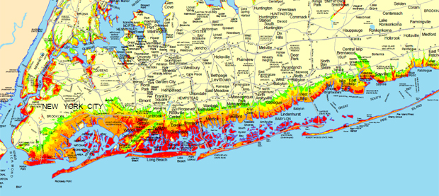
How do you prevent another storm from wreaking damage ($50 billion estimated so far) equal to or even greater than Sandy? If Sandy, a Category 1 hurricane could do this imagine what a Category 2 or 3 could co and then consider what kind of infrastructure would be needed to deal with such destructive storms.
What are the forces of nature we have to fight to keep the Atlantic Ocean at bay?

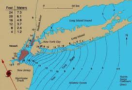
With Sandy it was much more than intensity, it was the immensity. And now this area has to rebuild. What should be done? Here are a number of initiatives that can harden the area to future storms and storm surges.
Re-Engineering the Shoreline
Because of the nature of the material content of the New Jersey, Staten Island and Long Island shorelines beach replenishment is a non-starter. Just piling sand on top of the areas eroded by storm surge will do little to ensure the durability and duration of any repair. Not only that, the cost of pumping sand up from offshore where the hurricane dumped it can be quite prohibitive. Once you start down this path it becomes an ongoing exercise.

Another traditional coastline rehabilitation technology is the building of groins (seen below) and jetties. Although successful as sand traps they prove to be ineffective against storm surges turning shorelines into obstacle courses.

The most commonly used defense for storm surges includes the building of seawalls and levees. It was poorly maintained levees that allowed Katrina’s storm surge to flood New Orleans. Properly built and maintained they would have prevented that Category 3 hurricane from inundating much of the city. A series of seawalls on Long Island, Manhattan, Staten Island and the Jersey Shore all failed during Sandy. They were not built high enough or strong enough to withstand the storm surge. If rebuilding of the walls is to be done, engineers may want to consider defense in depth with a combination of berms or levees and well anchored taller walls.

At best any beach shoreline re-engineering will prove a temporary fix as a line of defense against storm surges. It is the price of building on shifting sand.
Flood Gates
With 75% of the world’s population expected to be living in coastal communities by 2025 a more effective technology solution, than those described above, for combating rising ocean levels and storm surges is very much needed. And yet there are plenty of good examples of a technology that works already in place – flood gates. The Dutch have been building them for years allowing them to reclaim hundreds of square kilometers of land from the North Sea. The Thames River gates stave off potential flooding of London. Venice has been building new flood barriers to stop the Adriatic Sea from further damaging the city. Flood gates control the flow of the Mississippi River. And even New Orleans has them now to protect it from storm surges. So why not New York?

The cost of such a project is estimated at $15 billion, less than one-third of the estimated cost for cleaning up the damage caused by Hurricane Sandy.
City Internal Defenses
One proposal that has come out of Hurricane Sandy includes the development of a giant inflatable plug that looks like something out of a Woody Allen comedy. You can see it in the picture below.

The plug is just under 10 meters in length (32 feet) and 5 meters wide (16 feet). It can be inserted deflated into a tunnel opening and then quickly filled with water to effectively seal it off. Made from Vectran, a liquid-crystal polymer fiber, several could be placed in strategic locations to protect subways, roadway tunnels and other vulnerable sub-structure. Each costs $400,000.
To protect smaller underground accesses such as ventilation shafts technology can be designed to automatically seal entrances in the advent of a storm surge, further protecting New York’s infrastructure from flooding.
Building for Off the Grid
Urban living is heavily reliant on the energy grid. When it goes down it’s more than lights out. Elevators are inoperable. Appliances no longer work. Water pressure falls and without supplementary pumps is no longer available to apartment dwellers. Add to this the loss of transit like subways which rely on electricity and you have a pretty dysfunctional urban setting. That’s why cities like New York need to develop sustainable energy technology for high rise buildings in the event of a prolonged loss of power from the energy grid.
This can be accomplished using renewable energy sources like solar and wind. Apartment waste can be converted to energy using small cookers to heat water to drive turbines. Apartments could be outfitted with supplementary battery storage to cover the gaps when the sun is not shining or the wind not blowing. This would ensure continuous power for operating essential services such as elevators, air conditioning, common area lighting and water pumps.
Some buildings today in New York City are installing Otis “Gen2” elevators that use 75% less energy by feeding energy recovered from braking during descent and feeding it into the building’s internal electrical grid. Other innovations include blue roofs designed to capture rainwater for use in sanitation. A typical New York building outfitted this way could capture thousands of cubic meters of water for lots of low-flow toilet flushes.
]]>


