What are these risks? They include storms, floods, fires, heatwaves, rising sea levels and other extreme climate events accompanying rising atmospheric temperatures.
That $25 trillion bill doesn’t include the cost of retrofits and renovation to legacy homes to make them climate resilient and livable under changing conditions.
An American dream is to own a home overlooking a beautiful beach and water. If you watch HGTV’s “House Hunters” you certainly can see the attraction to pay a premium price for living by the ocean or a lake. Climate scientists, however, forecast that homes on the seashore will be vulnerable to rising sea levels, extreme weather events, flooding, and storm surges.
If you know Florida, it is extremely flat. Much of South Florida is only a few metres above sea level even when you go well inland. This area of the state will see a sea level rise of 0.9 metres (3 feet) by 2060 based on current trends. That number will likely double by 2100.
The Florida government estimates that 934,000 homes in South Florida will be at risk of being lost. The state has developed planning tools and studies but none of the actions taken by it or local municipalities is sufficient to stop an ocean inundation. No South Florida home by a beach or on nearby low-lying land will survive.
The aforementioned $25 trillion bill for Americans compounds many more trillions when we look at homes across the rest of the planet.
For example, China faces its multi-trillion-dollar challenge in the Pearl River Delta, near Hong Kong. This is Guangdong Province, home to 127 million Chinese. It is the economic engine of China and vulnerable to the same extreme conditions South Florida will experience. The Pearl River Delta includes the megacities of Guangzhou and Shenzhen. In the past month, both experienced severe flooding from one extreme precipitation event losing thousands of homes.
Projected sea level rise for the Pearl River Delta is expected to be 1 metre (3.3 feet) by 2100. The Chinese have been far more aggressive than South Florida’s government in hardening the infrastructure of the province to sea level rise and extreme weather risks. The investment may still not be enough to save millions of homes.
Globally, the economic toll of extreme weather and climate-change-related events continues to grow. China’s 2023 losses from torrential rains, landslides, hailstorms and typhoons in just nine months amounted to $42 billion. Africa from 1970 to 2021 has seen losses amounting to $43 billion. The European Union has reported its losses for the same period at $562 billion. South America’s hit $115.2 billion. By far the largest amount in losses, however, were recorded in North and Central America including the Caribbean nations reaching $2 trillion.
Somewhere in these multi-billion and trillion-dollar numbers, homeowners figure in. The World Bank, in its annual economic calculations for losses noted recently that it does not directly quantify homeowner and property value loss in its climate data. One study, however, covering a ten-year period ending in 2019 that looked at climate-related economic costs totalling $1.5 trillion, attempted to measure homeowner losses based on insurance claims and lost property value estimates.
At some point, homes that face heightened climate risk will become liabilities for private insurers to underwrite. Extreme weather claims will no longer be insurable in South Florida. Similar predictions in other jurisdictions include a Bank of England estimate that by 2050, 7% of UK homes will be uninsurable, and in Australia, the independent environmental advisory body, the Climate Council has forecasted one in 25 homes will turn the country into “an uninsurable nation.”
For private insurers still writing policies for homeowners in places like South Florida, future claims for climate events will likely be treated as “secondary perils” making them equivalent to “acts of God.” Claims will be denied. And as private insurers give up issuing policies, homeowners will turn to the state as the insurer of last resort. That’s already happening in Florida. Even then, however, the government as insurer doesn’t guarantee a homeowner will be paid should an extreme weather event occur. A growing inventory of uninsurable properties is the outcome which points to an unsustainable future where even the government will have no collateral upon which to base its payouts, particularly if the property is underwater.
]]>Five adaptation strategies are to be deployed:
So Miami-Dade plans to adapt to the changing climate since, on its own, this part of South Florida cannot turn back the ocean through mitigation. A multi-year $20 billion investment in capital projects and programs it is hoped will make the city resilient to the rising ocean. If no investment is made, a World Bank study that looked at a 0.4-meter rise (16 inches) over the next few decades would cost the region $25 billion per year. That’s why an investment of $1 now in mitigation will save $7 in the future.
Ten immediate actions include:
A large number of projects are already being implemented including the building of artificial reefs and breakwaters, raising of seawalls, greening shorelines with mangroves and preserving and expanding wetlands, getting rid of concrete and asphalt surfaces to increase the permeability of land, restoring beaches and dunes, and improving stormwater infrastructure.
There are holes in this plan. One of them is the public health issue related to the proliferation of vector-borne diseases like Dengue, Chikungunya, Zika, West Nile, and Malaria with the expansion of wetlands, canals, and stormwater containment. The mosquitoes responsible for the spreading of these diseases will find in the Miami plan ideal breeding grounds for disease spread with a number of these insect species capable of breeding not just in standing water, but brackish and saltwater as well.
Another hole is the passing reference to groundwater. Even when mentioned in this report, it largely addresses underground water table levels impacting stormwater runoff capacity. Rather than making this one of the top ten challenges, the report buries the issue of freshwater availability until page 118.
Why is this an oversight? Miami-Dade County sits on top of highly porous underground geology which I have written about here in the past. This geology is subject to seawater intrusion from the ocean. As sea levels rise, the separation of fresh and saltwater in the aquifer is also on the rise. It is anticipated within two decades, that there may be little to no fresh water in the aquifer beneath the city and county. Even now, Miami-Dade is drawing water from inland well fields a considerable distance from the city. These wells are less subject to intrusion for the moment. In the end, the ultimate answer will likely be billions spent on large-scale desalination of ocean water.
It should be noted that Broward County to the immediate north of Miami-Dade, and the home to the city of Fort Lauderdale, faces the same challenges and has issued its own plan to address sea-level rise. It, too, describes similar kinds of mitigation and adaptation strategies for which my wife and I have first-hand knowledge having visited this part of South Florida a half-decade ago. At the time it was clear to me that Broward was implementing half measures with no sense of urgency. Maybe that has now changed.
In April 2020, Richard Luscombe wrote a piece for The Guardian with the following headline, “Will Florida be lost forever to the climate crisis?” It is worth the read. In it, Luscombe notes that it took 31 years for the sea level to rise 0.15 meters (6 inches) in Miami. The next 0.15 meters will take only 15 years, and the next 0.15 meters after that, 15 more. That means Miami Beach could disappear in thirty years. The political will of the former Republican Governor of the state to address climate change was lacking. The current Republican Governor is slowly beginning to fund mitigation and adaptation projects. The clock on Florida’s survival as we know it is running out.
]]>The opposite of subsidence is isostatic rebound, a physical phenomenon which causes land to rise. Melting of land ice at the end of the last ice age is today producing a rebound effect in much of the polar regions of North America, Europe and Asia. The level of rise is measured in millimeters per century.
An interesting characteristic of isostatic rebound is the potential opposite effect it can have on other parts of the land mass where it is occurring. For example, if one part of a continent starts to rise does the continental plate compensate by tipping downward elsewhere?
Our children’s children may see isostatic rebound in action should Greenland ice continue to melt significantly in the next century. The island’s elevation will more than likely begin to rise while the water it discharges in the North Atlantic will submerge coastlines.
But I digress from the topic at hand which is to describe three areas of the Continental United States including Alaska that represent great risk to populations living there with discernible impacts likely to happen within the next thirty to fifty years.
So what are these areas?
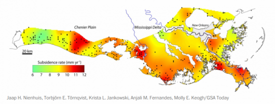
The first is Coastal Louisiana. A research paper published on June 14, 2017 in GSA Today, describes the “catastrophic rates” of loss the state is experiencing. In the past century alone the disappearance of Louisiana wetlands is equivalent to an area the size of the state of Delaware. What’s causing the subsidence? Human intervention on the Mississippi River such as the building of levees for flood control, and the straightening of the shipping channel, that is causing the delta to shrink and that impedes natural sedimentation from the river to restore shorelines. Add to this oil and gas extraction near shore and you have subsidence of the adjacent sea floor. Now combine that with rising sea levels in the Gulf of Mexico and you have the likelihood of dramatic physical changes to much of the coastline as well as implications for the future survival of the city of New Orleans. In the map appearing below, subsidence is indicated in millimeters per year with much of the coastline seeing annual elevation declines of 9 or more millimeters.
The second is Chesapeake Bay which includes the lower Potomac River Basin and Washington, DC. Chesapeake Bay is one of those areas of North America affected negatively by isostatic rebound in more northerly reaches of North America. For over 100,000 years ice covered much of the northern part of the United States as far south as the Ohio River Valley and Pennsylvania. The weight lifted 12,000 years ago and ever since Pennsylvania and parts of the Ohio Valley have been rising, tilting the areas to the south and east downward. Chesapeake Bay is the victim of this isostatic rebound and is continuing to subside for what is expected to last many centuries into the future. Combine the 1.7-millimeter rebound with mean rising sea levels of 1.7 millimeters and the land along the bay’s shoreline is vanishing. This is impacting the Delmarva Peninsula (Lower Maryland, Delaware, and Virginia), Washington, Baltimore, and Hampton Roads, the latter the home of one of the United States’ largest naval bases and air reserve.
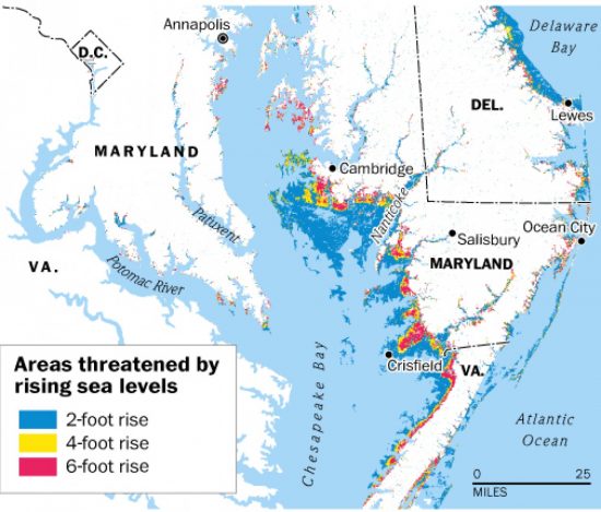
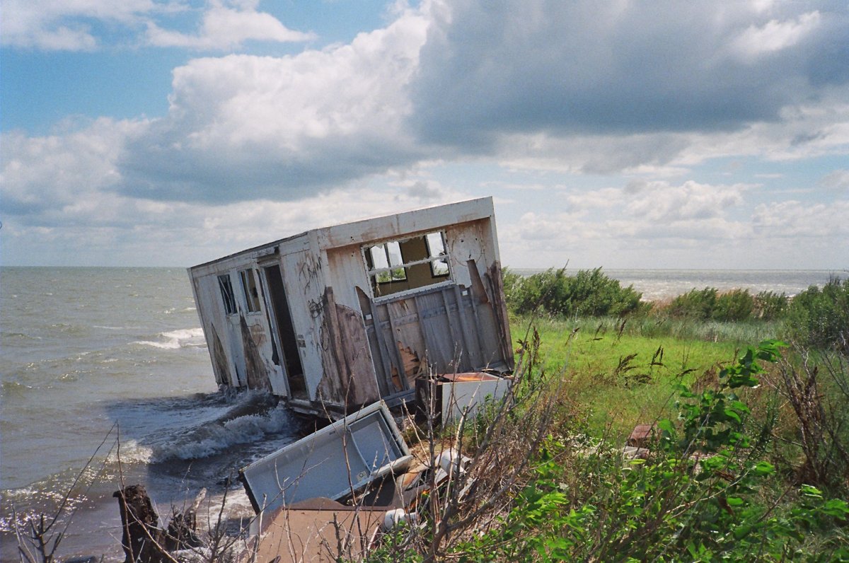
The latest Chesapeake Bay story made national news this week as the saga of disappearing Tangier Island. Located off the Maryland mainland, the island’s 450 permanent residents describe their home as “eroding away.” As largely pro-Trump in voting record, they don’t talk about climate change. Erosion is the operative word. And the rate is significant at over 4 meters (15 feet) of the island vanishing annually. Since 1850, the combination of both subsidence and rising sea levels has shrunk the island by two-thirds. And now sea level rise is accelerating the process making the island uninhabitable by 2040.
But President Trump called the mayor of Tangier to tell him he shouldn’t be concerned, that the island will be around for centuries to come. The President obviously doesn’t believe in isostatic rebound or climate change. For the Islanders, the promise of a $30 million seawall to surround what remains of their disintegrating homeland, was not forthcoming from the President. He’s saving money for the Mexican wall.
Our third at risk coastline is South Florida. From Maine to the Florida Keys, the sea levels are rising faster than almost anywhere else in the Atlantic Ocean Basin. And in South Florida, sea level rise is combining with a sinking freshwater table which is accompanied by land subsidence. The combination of the three presents a major threat to residents of the peninsula.
Much of South Florida today is a wetland, The Everglades. But human activity has tried to turn the area to agricultural production. In the process throughout the 20th century, the wetland has been drained to remove massive amounts of ground and surface water. The result, declines in elevation in many areas of as much as two meters or more. In fact, from 1967 to 2009, annual subsidence of more than a centimeter (0.55 inches) has been recorded.
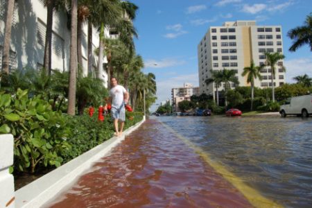
This isn’t the downward tilt to a more northerly isostatic rebound as is found in Chesapeake Bay. Rather it is similar to the subsidence of Louisiana’s coast, human derived. And when added to rising sea levels does not bode well for much of Miami and Fort Lauderdale without drastic feats of engineering to save these cities from inundation. Today even on sunny days the streets of Miami experience flooding. These used to be once in awhile events. Now they happen several times per month.
These three at-risk areas are not alone. It is estimated that 13.1 million Americans will be displaced from their homes by the combination of subsidence and rising sea levels by century end. Most live on the Atlantic and Gulf of Mexico coastlines. And although it seems like a long way off, the year 2100 is within two generations’ reach. That means those of you starting to raise a family today may see some of these communities inundated as your children begin families of their own. If you live in Miami or Fort Lauderdale, or Washington, DC, or New Orleans, those who follow two generations from now may not be given the same opportunity to appreciate what was once there.
]]>There are 70 species of mangrove in the world today. They occupy coastal wetlands largely in tropical and subtropical environments (see map below). They serve as nurseries for shellfish, crustaceans, fish, birds and other wildlife. They represent a significant renewable wood source. They absorb storm surges and prevent coastal erosion. They are salt tolerant filters. Their biomass is greater below ground than above which makes them effective sequesters of carbon. And with all these good things they are increasingly endangered by us.

The largest concentration of mangroves is found in Indonesia. In that country’s latest study researchers calculated the amount of carbon stored by these forests to be 3.14 billion tons with each tree storing 3 to 5 times the amount of carbon of any other tree species. And yet Indonesia is seeing massive mangrove deforestation. With 25% of the world’s remaining mangrove forests estimated at 2.9 million hectares (over 4.94 million acres) Indonesia is losing 52,000 hectares (128,500 acres) every year largely to shrimp ponds. The loss of mangrove acreage is contributing 42% to Indonesia’s carbon emissions contribution annually. If the country could stop this deforestation it could immediately see carbon emissions decline from 10 to 35%.
What is happening in Indonesia has already occurred in South Florida where mangrove forests are under pressure from real estate developers seeking beachfront locations for high-rise condominiums. The Florida Department of Environmental Protection describes mangroves as significant contributors “to the overall health of the state’s southern coastal zone.”
For Florida’s commercial fisheries mangroves are essential to the health of snapper, tarpon, jack, sheepshead and other fish populations. In fact without mangroves Florida might not even be there. And yet in many areas along the state’s coast mangroves have been destroyed. In Tampa Bay the loss amounts to 44% of the total habitat. Near West Palm Beach the loss is as much as 87%.
And now climate change is threatening mangroves as weather patterns change and the atmosphere warms. While a warming climate might appear to be beneficial to the range of the mangrove spreading it closer to the poles, with atmospheric warming has come ocean warming, and the latter is contributing to sea level rise and more destructive storm surges. For isolated mangrove forests it is becoming more difficult to hold back the sea.
Add incidents like the Deepwater Horizon explosion and spill of 2010 have seen mangrove mutation rates skyrocket along the Louisiana and other Gulf Coast state wetlands. In addition Deepwater Horizon has contributed to die offs and the weakening of mangrove forests further exacerbated by polluted runoff from coastal factories, cities and farms chemically impairing the trees. The consequence for much of the Gulf Coast – negatively impacted freshwater aquifers extending several kilometers inland.
Other impacts from mangrove duress in the Gulf, Florida and other coastal areas include:
The carbon sequestering property of mangroves is being further compromised as more forests get cleared. In leaving fewer mangroves the trees get larger increasing above-ground biomass. This makes them less efficient for capturing carbon because smaller more dense forests produce much larger sub-surface systems with better sequestering capability. In addition the larger trees means less of a living canopy and less biodiversity below the forest floor in associated waterways. The loss of biodiversity means less filter feeders to clean pollutants. It means the decline in water and soil quality and fewer juvenile fish which rely on the mangrove root systems for shelter from predators.
But there is a change in attitude beginning to make its presence felt in the world of mangroves. For example:
So what is the future for mangroves? With the rise in human population greatest in the tropical and semitropical world, and with most of humanity living at or near coastlines, mangroves are highly endangered. Aquaculture is expected to significantly increase to meet food demand. And where aquaculture sets up shop mangroves vanish.
As for climate change and its byproduct, rising sea levels, scientists are still studying potential impacts. Will forests move further inland as wave erosion and storm surges deplete coastal areas? In one 1997 study a rise of 16 centimeters (approximately 6 inches) in sea level initially caused seedling growth spurts but slowed once the trees reached the sapling stage after 2.5 years. That study didn’t look at erosion impacts from storm surges and coastal flooding.
I leave you with these three final notes and hope you have a renewed appreciation for the unique value that mangroves bring to our planet:
We need robust mangrove forests to grow and prosper in this 21st century, an important piece in our chess set of options to combat climate change.

Most of Florida’s drinking water, nearly 90%, comes from underground aquifers. Deep wells tap the aquifer for South Florida‘s large urban communities. On top of that South Florida gets over 150 centimeters (about 60 inches) rainfall annually. Those who manage the freshwater supply will tell you that keeping homes from getting flooded by freshwater each year remains a challenge in itself.
Much of the South Florida population resides on reclaimed Everglades’ land, land that normally would be a freshwater swamp. Residential areas here are peppered with lakes, lagoons and drainage ditches. Where we are staying close to the beach it rained last week and even here the water ponded on our street. So it would seem that with so much freshwater there should be no problem at all. But that is not the case. South Florida is booming in population. Water demand is increasing. And the wells that tap the aquifer are under siege.
Why? Take a look at the picture below. This is the rock that contains South Florida’s groundwater. It is a porous limestone. Normally one would think that rock like this would soak up freshwater like a sponge. But in fact the limestone is too easily penetrated by water. Any type of water. And that includes seawater.
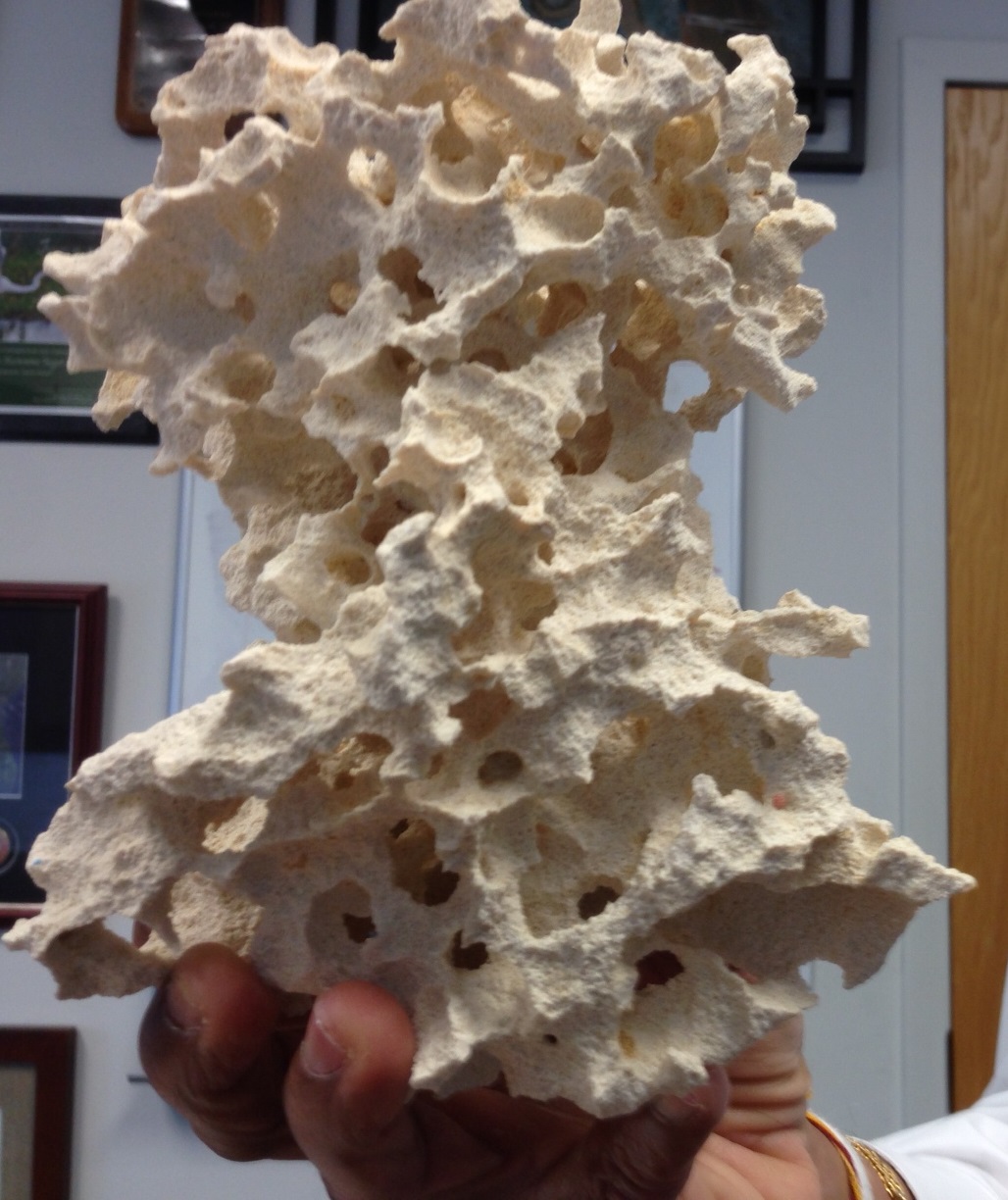
You see South Florida faces another problem where seawater comes into the picture. Sea levels continue to rise off the Florida coast and the trend is accelerating. Add to that the growing freshwater demand on the aquifer and you have a perfect storm with seawater displacing freshwater in the underground aquifers of the state.
The limestone aquifer has never been a barrier to seawater. There has always been salt water in the aquifer. It just lay further down because its specific gravity is heavier than the freshwater which flowed above. But rising seas means that below ground salt water is getting closer to the surface.
So it isn’t just storm surges off the Atlantic Ocean or Gulf of Mexico that threaten South Florida. The entire ocean as sea levels rise remains a threat. The salt water is moving both inland and upward, see illustration below, contaminating all those sunk wells dug decades ago and used by municipalities to provide drinking water.

So what’s in the cards for South Florida over the next few decades. Climatologists in studying current trends forecast a mean sea level rise of between 7.6 and 30 centimeters (3 to 12 inches). Flooding already on the increase will only get worse after heavy rains, storm surges and high tides. The water table in South Florida will creep closer to the surface posing an additional threat to homes and buildings. And of course as the water table rises salt water intrusion will further contaminate freshwater supplies.
For South Florida’s cities this is a train wreck happening at an ever increasing speed. Getting city, state and federal heads looking at the problem remains an enormous challenge. Recently I wrote about how the City of Miami Beach is addressing rising sea levels. With a limited tax base the city government has chosen to fund a storm deflection project by issuing permits to build 47 new beachfront condominium projects. Just south of us here in Fort Lauderdale, a $11.8 million US project is rehabilitating Highway A1A after a huge storm surge generated by Hurricane Sandy in late October 2012 led to the subsequent collapse of a four-block section of the roadway. But the new storm drains and slightly raised sea wall will do little to stop what is foreecast two decades hence.
So what do you do when you have millions of people living in the Greater Miami-Fort Lauderdale area with a disaster scenario creeping towards them centimeter by centimeter? Well if you are government it appears you do the least amount and the wrong things to boot until the “shit hits the fan.”
]]>


