Before I switched my university major to Medieval and Islamic history, I was pursuing a degree in geophysics. Geophysics studies the Earth and its physical characteristics. Back then my teachers described the inner layers of our planet as follows: there was the lithosphere or Earth’s crust and beneath it lay the mantle, a viscous hot zone that was described as being like a moving conveyor belt of melted rock. Underneath the mantle lay the core, consisting of an outer shell of dense hot liquid iron surrounding a solid iron core.
That picture has changed since the late 1960s with new research using seismic data providing us with a much more detailed model of what lies beneath our feet. It appears now that the mantle doesn’t directly lie beneath the lithosphere. A layer called the asthenosphere is an interface lying between the crust and mantle.
The asthenosphere is a relatively soft boundary between the lithosphere and upper mantle. Junlin Hua, a postdoctoral fellow at the University of Texas – Austin is the lead author of a recently published paper appearing in the journal Nature Geoscience that describes the role the asthenosphere plays in Continental Drift. The paper notes the following:
The asthenosphere extends from 100 kilometres (approximately 60 miles) to 700 kilometres (450 miles) beneath the Earth’s surface. It is described as being malleable, in other words, soft but not necessarily molten. When heat from the mantle causes greater viscosity within the asthenosphere, the continental crustal plates are given the impetus to move. Mind you, the movement of crustal plates is measured in millimetres to centimetres per year where there is geological seismic activity. Earthquakes like the ones that Turkey just had are usually a result of the plates locking together and then releasing in response to physical changes within the asthenosphere.

The Earth has an outer and inner core. The core was first discovered by scientists in 1936. It lies 5,000 kilometres (3,100 miles) beneath the surface of the planet. Measuring 1,220 kilometres (760 miles) across, the core was a mystery until seismologists studying the waves created by earthquakes noted that when passing through the centre of the planet, they slowed down. Subsequently, seismic datasets accumulated over time have allowed researchers to discern subtle changes in speed and direction allowing them to discover the first two core layers and now the innermost.
A study from Australian National University is credited with discovering the innermost core. This solid iron-nickel sphere has anisotropic characteristics. Anisotropic means depending on the sampling angle of seismological data, noticeable changes in the crystalline structure of the metal alloy can be detected. The authors of the study believe this suggests “a significant global event from the past” in which changes occurred to the composition and dynamics of the planet’s interior.
The anisotropic characteristics of the innermost core may be behind the beginning of plate tectonics. The variability within the innermost core structure could have affected the heat flow from the interior to the outermost layers of the planet, ultimately altering the dynamics within the lithosphere.
In our Solar System, plate tectonics is believed to be unique to Earth. There is no evidence of crustal plates on the Moon, Mars, Mercury or Venus. Europa, one of Jupiter’s moons, experiences similar crustal movement but the cause is currents in the ocean that lies beneath the ice crust combined with the pull of Jupiter’s gravity. Jupiter and none of the other gas giant outer planets show evidence of having crustal plates.
So what do we know now about the role of Earth’s core in the dynamics of our planet?
What appears to set Earth apart from other planets in our Solar System, as far as our discoveries show us to date, is that the crust of our planet consists of numerous floating pieces riding a viscous and fluid layer of hot rock, the mantle. Our continents are the most visible of these pieces riding the convective currents that have put them in motion.
Our landers and orbiters on Mars paint a very different picture of that planet. There the crust is rigid. This explains how a volcano the size of Olympus Mons can form and grow to super size, or how the canyon, the Valles Marineris can form and persist for billions of years. Features like this cannot exist on Earth with a dynamic and active crust.
Continental drift is what we call it and we can see the evidence of the past clearly on the imprint of the continental pieces today. We call them plates. The most visible continental alignment that shows how the continents have drifted is visible in the South Atlantic Ocean with the coastline of South America almost a perfect jigsaw match for Africa’s Guinea Coast.
But what set the continental plates in motion in the first place? What loosened Earth’s crust and not the Martian surface layers? The new hypothesis points to evidence in Earth’s early geological history. The planet endured two blitzkrieg events from its early formation some 4.5 billion years ago, to a second period around 3.9 billion years ago. These weren’t the only significant points in Earth’s past when large bodies of rock smashed into the young planet. Research from Stanford University points to as many as eight major impacts occurring between 3.5 and 3.2 billion years ago with the Moon prominently displaying some of the collateral damage that struck it during these bombardments.
We are not talking about an asteroid like the one associated with the demise of the dinosaurs 65 million years ago. These impactors make the dinosaur killer look like a pebble. The scars from that period in the Solar System’s early history can still be seen today on the surfaces of Mars, Mercury, and our Moon. But on Earth, they are nearly invisible for two reasons: continental drift, and erosion. For a big one here on Earth, look no further than Hudson Bay in Northern Canada encompassing an area of over 1.2 million square kilometres (470,000 square miles).
Geologists have always suspected that the early bombardments of the Earth set the continents adrift, but finding the evidence has been difficult. That’s what this discovery is attempting to validate. It involves the study of the oxygen isotope composition of magnetized zircon in rock formations in Western Australia, an area containing a continental remnant dating back almost 4 billion years. The evidence points to the start of a mantle being kickstarted by the deep impacts of large meteorites.
In an article posted on Curtin University’s website and written by Lucien Wilkinson, one of the authors of the published study, Dr. Tim Johnson, describes the mineral discovery at Pilbara Craton, the ancient continental remnant previously mentioned. He points to the evidence of these giant impacts in the tiny magnetized zircon crystals found in the rocks. He states further, “these zircon crystals revealed a ‘top-down’ process starting with the melting of rocks near the surface and progressing deeper, consistent with the geological effect of giant meteorite impacts…the first solid evidence that the processes that ultimately formed the continents.”
Dr. Johnson notes that what the research team identified in the Pilbara Craton is also similarly recognizable in other ancient continental remnants found elsewhere such as in Canada. The Curtin University research team hopes to test its hypothesis on these other ancient remnants to confirm it.
]]>My interest, however, in Earth’s formation and the movement of its crust has never waned. So when I read the article published online on November 10, 20201 in the journal Nature, I was intrigued and thought it would be a good topic for my blog.
If you are unfamiliar with plate tectonics, the movement of Earth’s crustal plates which form not just the continents, but the oceans floor as well, was first proposed by geophysicist and meteorologist, Alfred Wegener, who in 1915 published The Origin of Continents and Oceans in which he outlined a theory he called continental drift. Wegener’s evidence could be seen on world maps. The most striking example was the coast of South America, (see illustration below) which appeared to be a jigsaw match for Africa’s Guinea Coast. What Wegener didn’t know was the underlying mechanism explaining how this all worked over geological time.

It wasn’t just the map evidence that prompted Wegener’s hypothesis. He also noted that the geomorphology (the study of the Earth’s surface features) of Eastern South America and West Africa contained the same ancient rocks and formations which appeared to date back millions of years. And yet an ocean separated the two.
The hidden mechanism would later be revealed by oceanographers and geophysicists in the mid-20th century, a geological feature first noted in the mid-19th century at the time when transoceanic cables were being laid between Europe and North America. It was the Mid-Atlantic Ridge, the longest mountain range on the planet stretching from near the North Pole (87 degrees latitude north) and running the entire length of the Atlantic Ocean to Bourvet Island located to the south of Cape Town, South Africa.
The Ridge stands as tall as 3 kilometres (1.86 miles) above the ocean floor. It consists of a series of transform faults and a rift valley running along its entire length. Professor Wilson in 1965 theorized that the Ridge’s complex geological structure was the missing piece to explain plate tectonics, a geological formation caused by continental and oceanic plates sliding by, beneath, or over each other.
In the latest article in Nature, researchers from the Swiss Federal Institute of Technology Zurich, Yale University, and the University of Texas Austin, revealed what happens to those sliding crustal plates as they plunge into the Earth’s interior. The conveyor belt that moves crustal plates is the middle layer of our planet called the Mantle consisting of very hot, solid rock that exhibits considerable plasticity.
Geologists believe that the mantle is dynamic and that the Earth’s interior is slowly cooling. So what the state of the mantle was a billion years ago would be different than today.
The researchers began their study by creating a computer model of subduction, the term geophysicists use to describe the action of one crustal plate sliding beneath another. The results showed that the plates stayed largely intact for hundreds of millions of years. Seismic imaging of the deep Earth’s crust confirmed what the model showed.
Then the team changed the parameters by raising Earth’s interior temperature to conditions believed to have existed a billion years ago. The behaviour of the crustal plates changed with the plates breaking up fairly quickly (a few million years) after subduction.
This finding suggests that the behaviour of the crustal plates and their movement in the past was different from what is being observed in the present. The researchers pose a description of what may have been early Earth’s history when a hot mantle caused the crust to constantly break up unlike what we observe today. And only when the mantle cooled did the Earth’s crustal plates like the ones we see today establish themselves with the mechanism for Wegener’s continental drift emerging.
There are still several unknowns about the nature of Earth’s interior including the temperature of the planet’s core and the timelines associated with the first solidification and movement of crustal plates. But what the Nature article reveals is a dynamic surface that operates very differently from other planets in our Solar System.
]]>Yesterday, researchers from Brown University, in Providence, Rhode Island, had their paper accepted for publication in the Journal of Geophysical Research. Entitled “Porosity and salt content determine if subduction can occur in Europa’s ice shell,” the paper tries to explain observed features on Europa seen in satellite, Hubble, and Earth-based telescope images. The moon bears surface scars that strongly resemble those found on Earth along the margins of continental and ocean plates. In running computer simulations of the moon’s surface features, the Brown researchers hypothesize that forces similar to plate tectonics are happening there. It’s not quite the same as what drives Earth’s plates, but the end result is the same.
Europa’s icy plates are moving and there is evidence of subduction zones where the moon’s surface ends up sinking into the ocean beneath. States Brandon Johnson, Assistant Professor, Department of Earth, Environmental and Planetary Sciences, and lead author of the paper, “If indeed there’s life in that ocean, subduction offers a way to supply the nutrients it would need.”
Tectonics on Earth results from the interaction between our lithosphere, consisting of pieces of the crust forming distinctive plates, and the viscous, hot mantle that lies beneath. As mantle currents cause upwellings we see eruptions occur along the plate edges. The eruptions add new material to the Earth’s surface and push apart the plate edges, while on other parts of the Earth pieces of the lithosphere get dragged beneath into the mantle in a process known as subduction.
On Europa, the equivalent to Earth’s lithosphere can be found on the surface containing an outer and inner layer of ice. The outer layer is very thin with the ice much colder than the layer beneath. It is this second layer which the researchers believe acts like Earth’s continental plates. But figuring out the mechanism is the unsolved mystery. What causes convection of the inner ice layer?
The researchers hypothesize that convection can be explained if the inner ice layer is saltier than the ocean beneath. And if saltier it must, therefore, be denser. The difference in density between ice and ocean then becomes the mechanism driving Europan tectonics with plates of ice akin to the continental plates that compose Earth’s lithosphere. And as on our planet, where subduction immerses pieces of the surface into the mantle, on Europa, a different chemistry and geology produce a similar effect.
The evidence for a denser, saltier ice surface is there states Johnson. Geyser-like plumes erupting from cryovolcanoes bring salt to the surface where it continuously accumulates creating these denser plates of ice and reinforcing the tectonic processes. Johnson notes that the ability to study plate tectonics on Europa may help us to better understand Earth’s plate tectonic processes and how they began in the early history of our planet. And even more exciting, is how this mechanism on Europa could provide the means by which life, if it exists there, can be sustained.
NASA scientists at the Jet Propulsion Laboratory in Pasadena, California, are hellbent on getting to Europa to further investigate it to determine if it could or is harboring life. A mission called the Europa Clipper is planned for as early as 2022. It will send a robotic spacecraft similar to Juno to enter into a series of long looping orbits around Jupiter aimed at repeated flybys of the moon. The instrument payload will include cameras and spectrometers to study the surface, and radar to map the subsurface ocean. A magnetometer will measure the moon’s magnetic field and help to determine the salinity and depth of the ocean. A thermal instrument will scan for cryovolcanic eruptions and other upwellings including water plumes first noted in 2012.
A future mission tentatively scheduled for the late 2020s proposes to put a lander on Europa’s surface in 2031 to search for evidence of life. It would have to touch down near cryovolcanoes or water plumes if it wants to find microbes or other evidence of life expelled onto the surface. Scientists speculate that life on Europa would be similar Earth life observed on our oceans’ floors in proximity to thermal vents called black smokers, or akin to the microbial life found in subsurface glacial lakes.


The odd thing was the direction of the progress of the Moon’s shadow. It was opposite to the Moon’s orbit. Or at least that’s what it seems from my perspective here on Earth. The Sun and Moon both appear to rise in the East and set in the West every day. Through a lunar cycle, the Moon’s rise is later each night until it appears in the daytime, a ghostly semblance of its evening self. Remember neither the Moon or the Sun actually rise. It is the Earth that rotates clockwise as it orbits the Sun, creating the illusion of sunrise, moonrise, sunset, and moonset.
Well here’s the shocker.
The Moon actually orbits from West to East, that is counterclockwise to the Earth’s spin. That’s why the Moon rises later each day throughout a complete lunar cycle. And since the Moon is traveling at a very slow speed of 1 kilometer (0.6 miles) per second it takes it 30 days to complete one orbit of our Earth. And where the Moon goes so does it shadow. So itr passes in the same direction as its orbit and hence the path of the eclipse travels in the opposite direction of what we perceive to be the truth.

We are fortunate to have arisen as a species at a time when the relationship of size between Moon and the solar disk is perfect for eclipse events. It is as if some entity planned this to inspire humans to look up at the sky in wonder. But it is no more than a wonderful juxtaposition of fortunate timing and the relative size and distance between two celestial objects.
The Moon is a small rock compared to the ball of fire that is our Sun. In contemporary times it sits at a precise distance between the Earth and Sun to make an eclipse of the latter possible. If the Moon were smaller, or if its orbit was further away, we would never witness the coronal glow of a completely eclipsed Sun.
It wasn’t always the case here on Earth.
Back in the Cambrian Period, over 500 million years ago, the Moon’s orbit was far closer to Earth with a lunar month lasting a mere 18 days. An eclipse would have been a major life-threatening Earth event back then. Not only would the Sun have been obscured for several hours over a wide swath of the planet, but its direct alignment with the Moon would have combined the pull of gravity from both objects to create exaggerated tidal forces compared to today. Oceans would have risen as high as 30 meters (100 feet) during an eclipse event. Earth’s continental plates would have also felt the tug contributing to earthquakes, and other Earth-moving events. So we are fortunate to be a species insynch with the Moon and Sun’s orientation today. They are both just the right distance to make solar eclipses truly spectacular. And they are both the right distance to not turn our planet into an Earth-shaking terror ride.
Today’s eclipses may have gotten a few solar utility operators worried for a few minutes as their power source winked out. But other than that, the only threat came from human indifference to the advice given by scientists. They said, “don’t look directly at the Sun without protective eyewear during the eclipse until the Moon completely covers the solar mass.” Now if you don’t believe scientists, as in people like Donald Trump, then you can just go ahead and look all you want.

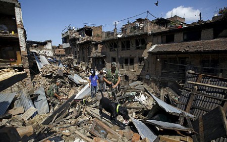
The earthquake that struck Nepal in the last weekend had a magnitude of between 7.8 and 7.9 on the Richter scale depending on different reports. So far the dead count is approaching 4,000 and climbing. A week before it struck 50 scientists visited Kathmandu to discuss how to prepare the city for a potential earthquake of this magnitude. What they didn’t foresee was the coincidence of their visit with the event that followed.
Nepal is a perfect earthquake zone say scientists. In the world of plate tectonics, over the last 10 million years Eurasia and India have been grinding against each other along a 2,900 kilometers (approximately 1,500 miles) front with India pushing up the Himalaya Mountains a centimeter (0.4 inches) per year. In the map image below we can the force and direction of the Indian plate using 1,867 ground-based sensors tracked by GPS satellites. This motion averages 2.5 centimeters (approximately 1 inch) annually along some of the segments.
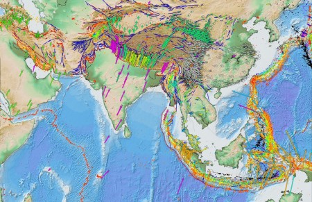
By plate tectonic motion standards this is considered pretty significant. In fact the Indian plate which broke off from Madagascar some 90 million years ago seems to be the record holder for plate tectonic speeds.
So if we know this why can’t we forecast an impending earthquake? After all the scientists who gathered in Kathmandu the week before the earthquake were confident that at some point one would occur. They were confident because the area has experienced on average magnitude-8 earthquakes approximately every 75 years. The last one was in 1934, 81 years ago. Yet this one happened without any means of us detecting it beforehand.
Today the science of earthquake detection remains primitive. We can detect plate movements using technologies like GPS, laser altimeters fired from satellites, and sensors placed on the ground. We have seismometers that may pick up early evidence of a major earthquake. And we can use radon sensors along a seismic fault to measure escaping gas. But with all that we cannot predict when an earthquake will strike and the energy it will unleash. We remain in the dark.
What we can do where we have dense populations living in prone areas is design and construct buildings that can absorb the energy and motion of an earthquake. In Kathmandu, sadly, that was not the case. The ancient city infrastructure was incapable of handling the earth shaking event even though Kathmandu and the government of Nepal had revised building codes in the last couple of decades to ensure new buildings were earthquake proof.
The real challenge, other than trying to predict an earthquake, is to get governments to act in earthquake prone areas in the best interests of their citizens. That means investing in infrastructure and buildings, from homes to offices, that are up to code. Poverty however is a great inhibitor to such noble pursuits.
And so the death toll in Kathmandu will rise as rescuers go through the rubble of the city and its surroundings. And as certain as day follows night, when Kathmandu rebuilds it will not be any better off in its ability to withstand a future earthquake because it will not have the financial means to address the problem.
James Jackson, head of the Earth Sciences Department, University of Cambridge, England, was one of those scientists visiting Kathmandu a week before the earthquake. He points out that living in this part of Nepal comes with many other challenges. In an Associated Press report he states,
“If you live in the Kathmandu Valley you have other priorities, daily threats and daily nasty things happen to you in terms of air quality, water quality, pollution, traffic and just poverty…..But it doesn’t mean that the earthquakes go away.”
Humanity has been extracting “stuff” from hillsides and pits for thousands of years. Mines pre-date the Neolithic Revolution by more than 30,000 years. From mines like the one that appears below to today the basic extraction technology has not significantly changed.

We have mined by finding resources on the surface. We have mined by digging tunnels and shafts into the ground. We have even recovered salt from the ocean using evaporation to harvest the mineral.
Currently surface mining is the predominant way we extract materials on this planet. Subsurface mining represents a small percentage of total mining activity. And today we are looking at mining the ocean floor. Let’s take a closer look at each of these mining technologies.
Surface Mining
Surface mining extracts 67.3 billion tons of raw material including metals, non-metals and coal annually. Of that amount 30 billion tons represents waste that is removed to get to the really valuable “stuff” that lies beneath. We quarry rock, sand and gravel to the tune of 23.5 billion tons for construction including 2.3 billion tons of material each year to for cement. Uncovering a mother lode and stripping out the ore has been and remains our most common mining technique to-date. In the United States, 98% of all metallic ores are extracted through surface mines. A typical surface mine is an open pit, a quarry or a stripped surface.
If you have never experienced a surface mine first hand it tends to overwhelm you. My first visit took place in 1965 when my high school class visited the open pit iron mine in Marmora, Ontario, about two hours northeast of Toronto. The mining company, Bethlehem Steel, had discovered a deposit of magnetite iron ore that was 33 meters (+100 feet) under the land surface, and therefore accessible by using open pit technology. To access the ore the company removed 73 million tons of limestone. The pit pictured below was a spectacular engineering feat. Its terraced sides served as a roadway upon which some of the biggest trucks I had ever seen crawled hauling raw ore excavated from the pit. I remember taking some sample magnetite home with me containing beautifully formed garnet crystals.

The ore body at Marmora was not large, spanning 850 by 220 meters (approximately 2,800 by 720 feet) and at its deepest reached 460 meters (1,500 feet) below the surface. It wasn’t highly concentrated iron either and therefore was crushed and pelletized as concentrate on site. You can see in the picture some of the processing buildings next to the open pit. At the time I first visited Marmora huge power shovels and bulldozers could be seen on the pit floor digging up raw ore. After 26 years the mine was no longer of any economic value and mining operations ceased. Today the abandoned mine sits like an open wound on the landscape slowly filling with water. Next to the pit lie mountains of waste material. One can find lots of Marmoras around the planet, abandoned pits accompanied by slag heaps, with little effort by the companies that did the mining and by the governments that granted mining licenses to do any environmental rehabilitation.
In the United States an even more extreme form of surface strip mining involves mountaintop removal. In 1998 the United States Department of Energy estimated that coal reserves in Appalachia amounted to 28.5 billion tons with much of it concentrated in Kentucky, West Virginia, Virginia and Tennessee. To get to these coal reserves companies have been applying for permits to blast the tops of mountains, disposing of the mining overburden in nearby valleys. Once the coal is removed the company plans include land reclamation and restoration. Many licenses have been granted in the past two decades but recently environmental concerns have slowed the pace of this type of mining. In January 2011, the United States’ Environmental Protection Agency vetoed a mountaintop removal permit being sought by one company in West Virginia. The reasons cited included concerns about environmental impact on water quality and aquatic life during the mining operation and after reclamation. Studies of other mountaintop mining operations showed that existing production and reclamation plans were contributing to environmental degradation that warranted a second look. This is just one example of what the future holds for surface mining in many developed countries.
In developing countries, however, the need to build infrastructure is driving exploration and the growth of surface mining with all its attendant environmental risks. In fact the United Nations estimates that by 2038 humans will extract 138 billion tons of materials from the Earth using surface mining techniques with much of the growth coming from the developing world.
Subsurface Mining
Subsurface mine operators sink shafts and dig tunnels in the Earth to reach buried ore deposits. Mines can be vertical shafts, horizontal tunnels, sloping shafts that can incline upward or downward or a combination of all of these depending on the shape of the ore body. Unlike surface mines that use big shovel and pail technologies, underground mining involves drilling, grinding, building underground rooms supported by pillars and shoring, removing ore, reshoring and following the ore face. Harder mined materials may require underground controlled blasting to get to the ore.
As high-grade ore deposits become harder to access subsurface mines are digging deeper into the Earth. This means more complex infrastructure for ventilation, temperature management and environmental safety, better and faster human transportation systems, the building of safe areas within the mine, and material transportation systems that provide rapid removal of mined ore and waste.
The deepest subsurface gold mines today in South Africa reach depths of 4,000 meters (over 13,000 feet or close to 2.5 miles). What is the environment like in deep mines? Temperatures of rocks exceed 60 Celsius (140 Fahrenheit). Slurry ice is pumped underground to cool the tunnel air to 29.5 Celsius (85 Fahrenheit). A mix of concrete, water and rock acts as an insulator within the walls of excavated areas to make the mine habitable.
Getting in and out of a mine at the depths we are describing can take well over an hour. In the event of an emergency mines are equipped with safety chambers (see the illustration below) for refuge.

The rescue of the 33 trapped men at the San Jose mine in Chile involved drilling a rescue bore hole to a depth of 680 meters (over 2,200 feet). In mines 6 times deeper think of the technology needed to save the lives of those trapped below.
Robotic Mining
As subsurface mining penetrates deeper into the Earth, and as mineral deposits become harder to access robots will not only be used to rescue trapped miners but will replace humans at the ore face. Robots in subsurface mining have significant advantages over us.

Humans will no longer need be exposed to the dangers of operating in the deep at the mine face, or be exposed to toxins leading to illnesses associated with long-term exposure to mining environments.
Ocean Mining
Exploiting the surface of the planet that lies underwater remains the next frontier for the mining industry. Just as oil and natural gas exploration moved offshore so will mining. Why?
Seafloor Massive Sulphide or SMS are deposits that form on the ocean floor near the edges of crustal plates. Associated with the hydrothermal vents known as “black smokers,” SMS deposits contain high concentrations of copper, zinc, gold, silver and other trace metals. They form when ocean water leaches into the cracks and rock fractures and undergos super-heating to a point where it dissolves the minerals in nearby rocks. When the super-heated water contacts the cold seawater above it the dissolved minerals precipitate on to the ocean floor creating massive deposits in the range of several million tons.
Companies and countries are just starting to exploit SMS laying claim to hundreds of thousands of square kilometers of the ocean floor. One company in Canada, Nautilus Minerals, is developing a project called Solwara 1 off the New Guinea coast.
What technology will humans need to develop ocean mining? The basic components already exist from technology developed for deep sea fossil fuel exploration and development. Robotic marine undersea technology can explore and mine SMS deposits. Piping systems and risers will serve as conduits for mined SMS combined with liquid to be pumped to the ocean surface for collection and processing.
Many countries are laying claim to SMS deposits. The following map illustrates the full extent of our 21st century mining future under the ocean.

Mining Off the Planet’s Surface
The 21st century will see our first efforts at mining near the Earth. From the moment that humans ventured to the Moon and Mars we have been studying their geological history, surveying their surfaces, creating radar and LIDAR images of subsurface terrain, identifying concentrations of mineral deposits, all with the idea of eventually inhabiting them.
When we finally begin to inhabit the Moon and Mars our first humans and robots will be miners seeking water for sustenance and for its byproducts, oxygen and hydrogen, then building materials for construction. The 21st century should see the first surface mining off our planet’s surface. Near-earth asteroids may become mining waystations to provide materials for constructing spaceships that will fly to Mars and beyond.
But we will look at space and the 21st century in much greater depth in an upcoming blog.
]]>


