Life on Earth came out of water. When searching for life in the Universe, we look for water and carbon. Where these two coexist, the chances for life seem possible. That’s why finding water, even the frozen type gets exobiologists excited.
Satellites, landers and rovers have all visited Mars. One of these is the European Space Agency’s (ESA) Mars Express which is entering its third decade of service giving us pictures and data from its onboard cameras and sensors. The Mars Express tells the story of the state of water both on and below the surface of the planet.
Its images and data point to the planet’s wetter past showing dried-up riverbeds and deltas. Mars Express has discovered a subsurface ocean of liquid water and large ice deposits beneath the planet’s red and dusty regolith. The latest water discovery is a large body of ice buried at the planet’s equator. The amount is so voluminous, that if it were to melt, the water would fill Earth’s Red Sea.
Mars Express has flown over this equatorial area of the planet in the past and imaged its surface features which ESA scientists now believe indicate the presence of water ice in vast amounts stretching as much as 3.7 kilometres underground. The amount is greater than what can be found at Mars’ two polar ice caps.
The location is the Medusae Fossae Formation (MFF) appearing near the centre of the image of Mars below. States Thomas Watters of the Smithsonian Institution in the United States, “Excitingly, the radar signals match what we’d expect to see from layered ice, and are similar to the signals we see from Mars’s polar caps, which we know to be very ice-rich.”

The MFF features wind-sculpted features, hundreds of kilometres across and several kilometres high. They have been observed as being one of the largest sources of the dust that blows across the planet’s surface.
The ice contained below the surface at the MFF site is interspersed with layers of dust, and topped by a hardened ash and dust coating, hundreds of metres thick. As a water source for future human missions, MFF is highly unlikely. Future colonists will need drilling rigs like those on Earth used to find oil and natural gas if they hope to reach the ice beneath.
What the discovery does reinforce is that Mars was once a water world similar to Earth before the lack of a strong magnetic field, and the solar wind blasted away its thicker atmosphere leaving a tenuous one that exists today. As the planet lost surface water and much of its atmosphere to space, a significant amount of the former turned to ice that was buried over time as the planet’s winds altered the surface topography.
So Mars had water that is now ice. Earth, too, has frozen deposits of water at the poles and high elevations. In Antarctica back in 2018, microbial life was discovered inside a glacier. The microbes were thriving in the deep freeze. Researchers estimate they have been there for as long as 25 million years.
Could microbes survive by hibernating even longer? Again we have evidence on Earth that shows microbes can remain in stasis for as long as 175 million years. They have been found beneath the surface of three continents that at one point were joined as part of the supercontinent Pangaea. So, if microscopic life can survive 175 million years, why not a half billion or even a billion years?
Mars, may not be a dead planet after all.
Both of these stories show that attention to detail in the 21st century requires humans practicing sophisticated science and engineering need to be more vigilant. For more about these 21st century fiascos read on.
Failing to Land a Probe on Mars
For a second time in the 21st century the European Space Agency (ESA) has failed in an attempt to deploy a lander on the surface of Mars. Both times all the efforts of hundreds of engineers and scientists went for naught because of botched engineering design or programming error.
Back in 2003 the ESA sent the Mars Express to the Red Planet with a British-built lander on board, named the Beagle 2. Mars Express entered into orbit around the planet in December 2003. The Beagle 2 separated from the orbiter and began a descent to the surface on Christmas Day. It was never heard from again and its fate was a mystery until its wreckage was spotted by a NASA Mars orbiter in 2015. The evidence shows that Beagle 2 got to the surface okay but that two of its four solar panels failed to deploy blocking its communication antenna from sending and receiving signals.
The design of Beagle 2 presented a recipe for potential failure. Rather than an elevated platform which would have given the solar panels greater flexibility in movement, the Beagle 2 was designed to land flush on the surface with the panels opening up like petals of a flower (see image below showing deployment of a replica of the probe).
But what might happen if the lander was too close to a boulder or on uneven terrain that could impede a panel or two from opening? Nobody in the engineering team that built Beagle 2 had insight into recognizing this as a potential design problem.

With ExoMars, the lander named Schiaparelli, was not designed the same way as Beagle 2. The landing technology was different from that used by successful NASA Mars missions that placed Spirit, Opportunity, Phoenix and Curiosity on the surface of the planet. When Schiaparelli began its descent to Mars it used aerobraking and heat shield technology (see illustration below) combined with a parachute to help it make it to the surface. The decision-making software on board could assess the doppler radar and altimeter readings during descent and make corrections to the control thrusters and determine when to release the parachute for final landing sequence.
Preliminary analysis of what happened indicates that the navigation software erred in its reading of the data being fed to it by the altimeter and radar resulting in a preliminary release of the parachute. The landing thrusters fired thinking the probe was just within a few meters of the Martian surface when in reality it was descending at an altitude of 3.7 kilometers. The end result a crash landing on the surface that destroyed Schiaparelli.
Engineers at ESA were successfully able to produce the same error reading in computer simulations after the fact. Too bad they didn’t fully anticipate such an event by providing on board system error correction and validation routines to save the probe. Fortunately the ExoMars was successfully inserted into orbit just like its predecessor Mars Express.

The Symbol of New San Francisco is a Tower of Glass That’s Sinking
Completed in 2008, San Francisco’s Millennium Tower was supposed to be the place for the rich and famous to live. When first completed, the 58-storey building seemed to be designed to meet the standards of the civil engineering codes developed in earthquake prone California. But the architects and engineers didn’t consider the underlying geology upon which the building’s foundation would rest. Turns out Millennium Tower is built on mud-filled unstable ground near San Francisco Bay’s original shoreline. This is reclaimed land.
Usually when designing a skyscraper the engineers anchor the foundation in underlying bedrock. Not Millennium Tower’s design team. Instead they anchored their glass tower driving piles into approximately 25 meters (80 feet) of dense sand and then laid a concrete slab on top. This was a cost-shaving measure since the bedrock depth was 60 meters (200 feet).
Skyscrapers do settle after construction but Millennium Tower is settling and tilting at a rate that equals what was anticipated in its expected lifetime within the last seven years. When design certified the building was expected to subside by no more than 10 to 15 centimeters (4 to 6 inches). Instead it has sunk ovwer 40 centimeters (16 inches) and is still going down. To compound the sinking the building is leaning over 5 centimeters (2 inches) and no one knows where it will stop. If you want to witness just how much of a tilt watch one building unit owner’s video of a rolling marble.
Compounding the engineering mistake made in the design and construction of the foundation is the fact that the building is made of reinforced concrete, described by some as “uniquely heavy for such a tall structure built on landfill and not anchored to bedrock.” Supposedly the choice of material was to compensate for not reinforcing the foundation base by drilling to the bedrock. Now it appears that the material choice may be further contributing to the building’s declining elevation.
In the latest twist, an observation satellite, Sentinel-1, in scanning the city surface from space using its on board sophisticated radar designed to detect subsidence hotspots in earthquake prone regions, has detected the rate of downward displacement and tilt which is ongoing.
In the satellite image below Sentinel-1 data displays areas with no detected ground subsidence in the colour green. Areas appearing from yellow to orange to red shows the rate of sinking. The tower location can be seen just to the west of the San Francisco-Oakland Bay Bridge near the top right of the image.

What makes this engineering fiasco even more of a total screw up is the fact that building inspectors from the city apparently knew about the problem and yet didn’t inform the public or those purchasing condominium units in the building. And then to top it off the city decided to build a new transportation hub right next to the Millennium Tower further contributing to the building foundation’s instability. And there appears to be no easy fix.
Will Millennium Tower become a tourist attraction like the Leaning Tower in Pisa? Only time will tell. Of bigger concern is earthquakes and their potential impact on the stability of the structure.
Sentinel-1 has observed many other human-engineered projects that are potential nasty surprises for those who rely on them as places to live or work. For example the Oslo train station appears to be another building experiencing severe subsidence. Between it and Millennium Tower we are creating an entirely new science – deformation studies.

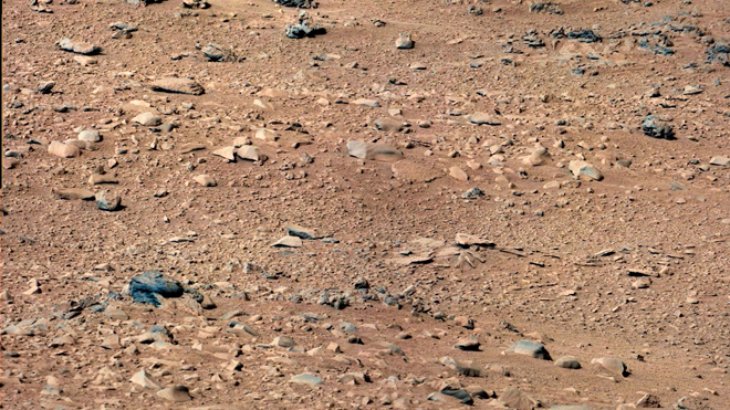
Today I focus on three Mars’ stories. One involves a Curiosity image of a rock that looks like a rat scurrying about on the surface of Mars. First reported by a Japanese blogger with an active imagination, the story soon showed up in major news media and made the rounds for about 24 hours. All I can say is that lighting and shadows can do so amazing things in a photograph.
Judge for yourselves what Curiosity saw. The likeness of a rat appears sandwiched between two rocks roughly two-thirds from the bottom of the picture below on the left side. If you look closely there is a rock below the rat that looks like a severed fish tail. I wonder if the rat caught the fish.
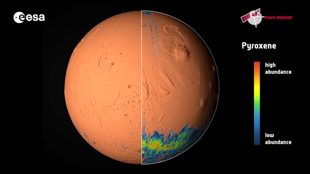
On to more serious Martian announcements. Of greater importance in the last week, a Martian spacecraft celebrated a decade in orbit around the planet – the European Space Agency’s (ESA) Mars Express. In celebration ESA released a video atlas of the planet featuring a map showing the planet’s complex geography and geology, and highlighting mineral distribution in deposits produced through vulcanism, past water events and ongoing wind and dust storm activity.
An added bonus from Mars Express‘ ten year coverage of the planet are its many close encounters with Phobos, the Martian moon. One of those encounters in 2010 took the spacecraft to within 67 kilometers (less than 40 miles) of this captured asteroid. The video by Mars Express in another Phobos encounter dramatically shows the moon passing in the foreground with the planet Jupiter behind, a truly remarkable piece of footage.
For a mission that upon its arrival near Mars began with its lander, the Beagle 2, crashing to the surface, Mars Express has since been a ringing success. It is expected to operate for many years into the future giving us an unparalleled view of the planet surface while keeping an eye on Curiosity and NASA’s nine year wonder, Opportunity. Last month the latter achieved a new milestone surpassing 35.76 kilometers in travel distance since arriving on the planet. Only Lunokhod 2, the Soviet rover of 1973 has outdistanced it having achieved 37 kilometers on its lunar mission.
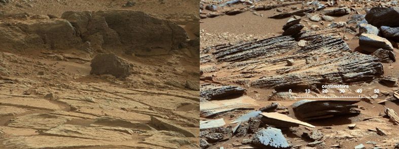
And speaking of Curiosity, it has experienced ups and downs of late with a number of shutdowns and reboots to shakeout some of the bugs that seem to have plagued it. It has drilled into two rocks and extensively photographed what appears to be ancient stream beds. In total it has traveled less than a kilometer to date (about half a mile). But now it is ready to start doing some real long distance driving across the bottom of Gale Crater and on to Mount Sharp at the crater’s centre. The route has been mapped and it is expected to take about ten months to travel the 8 kilometers (5 miles). Why so long? Because Curiosity will make stops along the way. For example it has a planned stop to examine the remains of some of the landing gear that got it to Mars. It will do more drilling of interesting rock samples. Plans include checking out two rock formations, one called Point Lake (seen below on the left), the other given the name Shaler (seen on the right). Both appear to be remains of rocks formed by chemical or wind-induced weathering.
And that’s the real news from Mars. And now back to unpacking here on Earth.
Thanks for dropping by.
]]>