In this posting, Jane describes a function of the technology that is common to smartphones. Every month my Android phone tells me where I have been. It only knows my location if I carry it. A-GPS chip built into the phone listens for the GPS satellites located in low-Earth orbit and as each passes overhead a combination of four or more calculate my approximate phone location and thereby, me.
But I will let Jane tell you how geolocation technology has morphed into geofencing.
Don’t be fooled by the term geofencing. It has nothing to do with rock collecting or sword fighting. Instead, it’s about using location-based services on people’s phones or drones to track their whereabouts. When you know where a person’s device is located, you know where they likely are. You can then send targeted advertising, monitor work activity or even warn them if they and their phone are entering unauthorized airspace.
In this posting, I describe geofencing’s most interesting uses.
A geofence is an invisible boundary drawn around a geographic area. It can be a city district, a building, or even a room. Geofencing uses geolocation which identifies the IP address of a device containing an A-GPS chip. Without geolocation, you cannot set up a geofence which can trigger an action when the device you are using enters or exits a virtually fenced area. Set your phone to enable location-based services, and you can be geofenced.
Drone enthusiasts should take note. If you fly your device above a military base, airport or prison in the United States, you will likely cross a geofence and prompt a geolocation alert. In the best-case scenario, a phone will receive a message informing you that you are in restricted airspace and advise you to turn back. Many no-fly geofenced zones, however, don’t send out a warning and can disable a drone. In this case, the drone will drop from the sky like a rock once it crosses the virtual boundary. So watch where you fly!
Know the whereabouts of vehicles equipped with a GPS-based fleet tracking device connected to a geofence. This is particularly important for vehicles delivering hazardous materials or time-sensitive packages. A lost shipment of explosives like fireworks, airbags or dynamite can present a massive liability. Geofencing lets you see when the vehicle has made it to its destination safely.
Geofencing can be used to create highly targeted advertising. For example, when you walk into a concert venue, you start getting promotional ads for tickets to a future event. When walking through a mall, your phone sends you menu offerings from the local food court. Walk into a store with geofencing and you receive a message promoting what’s on sale. A precaution, athough this method of advertising is effective it can also be very expensive.
Imagine a car dealership with a rival across the street. How can you use geofencing to attract the rival’s customers? Draw a geofence around the competition. That way when a potential customer crosses the virtual boundary you created, they will receive advertising on their phones from across the street. Hence the term, geoconquesting, a way to take location-based marketing to the next level.
It’s equivalent to putting up an advertising sign directly in the competition’s lobby. The only difference? The competition cannot remove it.
Companies use geofencing to monitor employees’ locations, a practice that has become more popular with the advent of remote work. For example, the Hubstaff mobile app uses screenshots paired with GPS data to determine where remote employees are working for the day.
Employers can also use geofencing to automatically clock workers in and out based on their location. When a staff member enters an office with a geofence, a time-tracking app opens and allows them to start logging their hours for the day. When the employee leaves, the app clocks them out.
A proposed use for geofencing is to pair the technology with firearms. Location-based guns would be unable to fire beyond a geofence. This would be useful for shooting ranges, hunting lodges, or in designated home spaces. Once the weapon goes beyond the virtual fence, it can no longer fire. This could help to prevent gun theft and armed robberies while still letting people own a gun for recreational use or hunting.
How do you know your location-based advertising is working? One way to measure its effectiveness is to count the number of phones receiving ads. Then track how many remain in the location after receipt. In this way, you can see if your geofencing campaign is driving foot traffic.
Because geofencing could be considered an invasion of privacy, many governments have enacted laws to regulate it. For example, the states of Washington and Nevada have passed regulations prohibiting geofencing around medical facilities. Connecticut bans geofences within 1,735 feet of mental or reproductive health clinics. The goal here is to protect patient privacy.
Ensuring marketers don’t use geofencing to promote products and services without understanding the potential harm it can do is leading more governments to enact regulations on how and where it can be used. In other words, geofencing’s use needs guardrails or a fence to remain effective as a targeted geographic marketing tool.
Geofencing isn’t just for marketers. As we have already described, it can monitor vehicles, automate time tracking and even protect sensitive locations from unwelcome visitors. But here are some future applications to consider:
Can you think of other ways geofencing can be used? Write back with your ideas and comments to let Techso Mogro know.
]]>
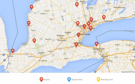
Any area deemed a national security location can be programmed to become a no-fly zone for DJI drones. The company has pre-built a database of geofences. The map below highlights no-fly zones for the Greater Toronto area and Southwestern Ontario.
The company believes that by providing this feature they are anticipating future U.S. Federal Aviation Administration (FAA) flight regulations for drones. Drones are expected to be one of the biggest Christmas sellers in 2015 and according to most recent forecasts are expected to pass the million unit threshold before year end.
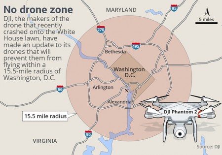
The DJI proprietary software in its latest iteration is expected to go live in December. Default drone settings include full restrictions over areas described above. Users, however, can open a DJI account and self-authorize flights disabling the geofencing feature. In such cases DJI advises users that any violation will lead to the company sharing user information with legal and security authorities. Only one zone is not subject to override. That’s the restricted no-fly zone over the American capital. Other drone manufacturers are expected to follow DJI’s lead and several have joined an FAA body tasked with establishing U.S. flight rules for drones.
Some have raised objection to what DJI has done stating that no other technology has prebuilt geofencing. They argue that when you get behind the wheel of an automobile there is nothing limiting you from driving as fast as you like and where you like. It is the obligation of the driver to follow the rules. The argument, however, doesn’t hold water for all vehicles, particularly trucks and buses fitted with governors that cut in when a driver exceeds a predefined speed threshold. And of course autonomous vehicles and collision avoidance and early warning systems are further weakening the argument as more manufacturers take driver “free will” out of the equation.
]]>