The data leading to these forecasts combine observed satellite altimeter and Earth-based tidal gauge measurements. Satellites have detected accelerating rates of sea level rise since 1993 which suggests the higher numbers in these forecasts will be closer to the likely outcome.
For coastal towns and cities, the foreknowledge should allow them to consider one of two strategies:
Rising sea level is associated with global climate change. As atmospheric temperatures rise, so does the temperature of the ocean causing thermal expansion. Also, a warming atmosphere causes glacial melt which today can be observed both in alpine and continental glaciers.
But there is something else playing a part. That’s the Moon. Every 18.6 years the oceans of the world experience higher tides because of what is a wobble in our lunar companion’s orbit. The wobble causes higher tides in one part of the cycle, and lower tides at another point in time. The 2030s should have us at the high point just when global warming will likely have exceeded 1.5 Celsius (2.7 Fahrenheit) in mean temperature rise, the IPCC’s stated low-threshold target that it wants us not to exceed. Not to throw a wet sponge on this, a new forecast states that the next El Nino cycle beginning in 2024 may push us over the 1.5 mark, a frightening consequence coming from our procrastination to address climate change.
Although the reports are foreboding, NASA wants to help homeowners and community planners to better deal with the threat of sea level rise. It has established a Sea Level Change portal as well as a Sea Level Projection Tool to provide real-time observations and global projections that go out as far past 2150. These projections cover six different climate models looking at the latest scientific research and data collection for ocean thermal expansion, alpine, Greenland and Antarctic deglaciation, and contributions from other land water storage sources (rivers, lakes, aquifers).
For homeowners and municipal planners of coastal communities, the coastal threat is being well documented by science. Those contemplating ownership of a home next to the sea should be going into these types of transactions with eyes wide open. But rising sea levels seem to have little to no impact on coastal home purchases.
A new publication, “Housing Market Response to Sea-Level Rise in Florida,” written by Georgia State University professors Risa Palm and Toby Bolsen illustrates just how little sea level rise is impacting consumers. In a survey of 680 Miami realtors, the researchers asked if buying and selling of homes were being influenced by new flood maps that projected future areas of risk in South Florida. The realtors surveyed stated that the market remained hot for coastal properties and that they were optimistic about future sales even though media coverage in South Florida continued to report stories on sea level rise.
When asked about property insurance, realtors noted that there may be a time in the future when the risk cost could negatively impact sales. But coastal property purchases, they stated, were not about the risk for most buyers, but rather about the amenity of being by the sea.
Despite realtor optimism, the cost of flood policies continues to rise as do the minimum deductibles. Is this uniform across all U.S. seaboards? No. In some high-risk-identified flood zip code areas, some insurers have stopped offering policies. But most continue to provide give high-risk areas with insurance coverage. What’s changed is that insurers are instituting stricter underwriting guidelines making it more difficult to qualify upon renewal which then leaves homeowners dependent on government relief in the event of a flood. Other insurers are providing homeowners with guidance about home upgrades to plumbing, electrical and HVAC systems, and even flood protection landscaping advice.
There will be a tipping point when insurers and homeowners will no longer find common ground. But based on the Georgia State study for South Florida, we are still not there. But as sea levels rise into the 2030s, that tipping point may soon arrive.
]]>
Florence was but a taste of what Americans will experience in their homes by the end of this century. The forecasts should not be ignored. What do they indicate? Regular flooding will affect 4.7 million living in 2.5 million properties. Total cost, not $22 billion but rather over $1 trillion. Among places impacted will be tourist destinations like Hilton Head, South Carolina, where $1.5 billion in current property value will be underwater by 2045.
How real is this? Consider Charleston, South Carolina, one of America’s most flood-prone cities (when we visited the city a few years ago, the downtown market area experienced a sunshine flood during high tide, apparently a regular occurrence). Home values in Charleston are already reflecting the uncertainty associated with future sea-level rise and have declined in value by $266 million since 2005.
The Carolinas are not alone in facing rising sea levels along the Atlantic coast of the United States. Southern Florida and the Everglades, Central Florida from the Atlantic shore to the Gulf of Mexico reaching inland to Orlando, New Orleans and much of southern Louisiana, Washington, DC and Chesapeake Bay, New York City and parts of Long Island, and Boston’s Back Bay and the Fens, will all be caught up in the same precarious real estate dilemma as coastlines become inundated.
A friend of mine, who works in finance, reminded me of all of these prognostications which I have referenced in numerous postings at this site when he sent me an article written by Geoff Dembicki on November 1st for Vice. Entitled, “A ‘Big Short’ Investor’s New Bet: Climate Change Will Bust the Housing Market.” It tells the story of David Burt who predicted the 2008 sub-prime mortgage debacle, and who now is gambling on history repeating itself soon with climate change becoming a driving force behind a future real estate crash rather than the speculative mortgages and corrupted banking system that caused the last crisis.
How Burt envisions this repeat of history is to imagine coastal real estate in the form of a brand-new condominium beachfront apartment. Always seen as prime real estate, the building site is given the construction green light based on historical flood zone maps drawn up by FEMA and several decades old. Investors line up and buy all the units in the building. The lower floors are occupied by middle-income families. the penthouses are actively traded by banks and well-heeled investors. Burt sees the entire building as a high-risk venture because of climate change. In Dembicki’s words, he states the building would be “teetering in the ocean wind.”
When a building like this is erected along a shoreline its units come at a premium price. But Burt argues that climate change impacts make premium pricing, mispricing.
As a result, he has started a new investment firm focused on coastal and flood-prone real estate threatened by climate change. He anticipates a plunge in value that will mean housing units will not only be overpriced leading to significant financial overexposure for homeowners whose mortgages will be greater than the homes are worth. For the agents that underwrite these bank-issued mortgages, Freddie Mac and Fannie Mae, funded by taxpayers, this represents an impending foreclosure bomb.
Why is this happening?
Because 75% of FEMA flood maps are currently out of date, having not been revised since the 1970s before climate change became a reality. In the past when a home was built in a floodplain area deemed high risk, flood insurance issued by the federal National Flood Insurance Program could be purchased. Premiums where risk was high were set at high rates to discourage builders and buyers from developing and purchasing such properties. Thus the insurance mitigated the risk. But today’s FEMA maps no longer carry any weight when it comes to sea level rise and extreme weather event frequency. When you consider that America’s coastlines are already seeing record high sea levels and more frequent flooding, FEMA has been woefully deficient in doing its job and as a result has put many homeowners at greater risk.
Just how much greater?
The Union of Concerned Scientists (UCS) has calculated an estimated 311,000 homes along America’s coastlines are currently at risk of chronic flooding over the next thirty years. What’s the value of these properties in the long term? Zero. And yet most of them are funded by overpriced mortgages that the homeowners will be responsible for discharging for what will be in effect worthless properties.
When Hurricane Harvey stalled over Houston in 2017 it destroyed tens of thousands of properties. Many were built in areas that should have been deemed high risk flood plain. Most, however, were not required to have flood insurance because FEMA maps didn’t designate the requirement. It’s a wonder that Harvey didn’t create a massive foreclosure crisis at the time.
Burt points to Houston and Harvey as the tip of the iceberg. Homes along America’s seacoasts are still being issued mortgages despite the financial risk they represent. And the mortgages being issued are being underwritten by taxpayers through Freddie Mac and Fannie Mae. So we have the makings of a foreclosure crisis with a drop in home values brought on by climate change. And unlike the foreclosure and sub-prime mortgage crisis of 2008, there will be none of the rebound that followed as housing prices slowly recovered.
Why not? Because many of these homes will no longer be saleable, and some will be underwater. In Dembicki’s article, he quotes Burt, “I love the environment and nature and much of my joy in life comes from going for walks in the woods or on the beach with my family,” he said. “We have no idea how bad things really could get, there’s far bigger risks associated with climate change than depreciating home values and some of them are just really, really scary.”
Where the UCS talks about 311,000 homes at risk, the actual numbers are actually eight-fold higher at close to 2.5 million at present, and represent, as I have stated previously, trillions of dollars in what could eventually be properties with no value whatsoever and the American people stuck with a massive unpaid debt. Will the Fed be able to bail out Freddie Mac and Fannie Mae one more time? Or will the entire economy come crashing down. Burt is selling short because he sees the evidence unfolding before him. The question for the American government and other jurisdictions is, do they not see the approaching climate and financial storm?


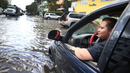
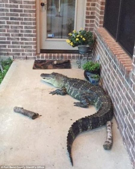
And in Southern Florida after Hurricane Irma, the storm surge and rain produced alligators on roadways, water snakes in people’s backyards, and an occasional octopus swimming around in city parkades.
For those who stay behind and rebuild, there are others who have reached their limits and decided to move elsewhere. It is fair to say that climate change, extreme weather and other natural disasters rather than economic determinants will be the fuel for human migration throughout much of the remainder of the 21st century.
And as nations fail to achieve significant carbon reductions this phenomenon will accelerate not just in the United States but in almost every country impacted by rising sea levels, rising temperatures, and rising weather extremes.
Today 4 in 10 humans live 60 kilometers (37 miles) or less from the world’s oceans. More than 1 billion of us live in areas with elevations above sea level of less than 5 meters (16 feet). The vast majority of these people live in Asia. In the United States, the population living along or near the coast exceeds 130 million.
I have stated before on this site that if you want to fully comprehend the impact of climate change ask insurance underwriters. These companies that reinsure the insurer of your home measure the cost of climate change annually. They are calculators of risk and right now they are raising costs to insurance companies who provide policies to homeowners who remain in areas deemed most likely to be inundated as sea levels rise. If you are contemplating buying a beachfront property or planning to build one, the sticker shock you’ll experience for flood protection should make you think twice. And if you are not putting new construction on stilts, then you may not even qualify for these inflated premiums. Whereas insurance companies, banks, and other financial lenders act because of rising risk, it appears, to-date, that governments continue to fail at recognizing the risk to their citizens.
In doing the research background to this posting I came across an article appearing in Newsroom, a New Zealand publication. Written by Eloise Gibson, Newsroom’s environment, and science editor, and appearing on January 15th of this year, she writes about Belinda Storey, a climate risk specialist in her country that has been studying how government, insurers, and homeowners need to adapt to rising sea levels. Storey notes, “A lot of people focus on, when does the probability [of flooding] become an annual event or a daily event. But that is not the most important question…..The most important question is, when does it reach that insurance threshold?” So that threshold when insurers withdraw from the world’s coastlines is only a matter of when and not if.
Storey is working with a team of researchers at Victoria University, in Wellington, New Zealand, to create a roadmap predicting areas of greatest risk in her country. She believes that the insurance thresholds when they withdraw are much sooner than most people realize. A 10 centimeter (about a 4 inch) rise in ocean sea levels off New Zealand’s coasts turns the 1 in a century flood event into a 1 in 20 years event. And that’s just sea level rise incidents and does not include additional extreme weather storm surges which will impact New Zealand’s coastlines.
Where does the government of New Zealand, or for that matter any national government, fit into the equation of risk? Likely when the government facing the rebuilding costs of coastal infrastructure finally gives up.
States Storey, “Property effectively has a time limit on it now….the value won’t go to zero immediately, because there will still be people who want to live, work and play at the coast, even if….risks increase.” But when governments say they can no longer repair repeatedly damaged roads, and rebuild the pipes to deliver fresh water, and remove sewage, then the migration will inevitably begin.
For New Zealanders, Americans, Europeans, and many others the migration won’t be a decision driven by a lack of insurance coverage, but rather by basic Malthusian-defined needs which will go wanting as oceans rise and extreme weather events take their toll.
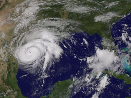
This isn’t the first hurricane to strike the Texas coast. Back in September of 1900 before the existence of a comprehensive weather service in the United States, a Category 4 hurricane struck Galveston flooding the entire city which stood on average a mere 2.75 meters (9 feet) above sea level. That hurricane which happened before hurricanes were given names, unleashed a storm surge 4.5 meters high (15 feet). No one actually knows how many died that day because it was a Labour Day weekend. There was an ongoing fair which attracted out-of-towners. And because there was no accurate count of people in transit in and out of the city. At the time Galveston was the third largest port in the United States. The numbers between 6 and 8,000 represent the rough estimate of deaths. The damage to the city was permanent as Galveston soon became a minor seaport with Houston replacing it as the primary destination for ships on the Gulf of Mexico.
At the time of the Galveston hurricane, the military ran the weather service in America. Those assigned to local forecasting were soldiers who relied on no more than telegraph lines, cloud charts, readings from barometers and anemometers, and what they could see from their weather stations. Today the United States has a number of satellites in orbit dedicated to studying global weather. Hurricanes can be watched from conception to death. Storm tracks can be plotted with accuracy. Sophisticated weather simulators can compile data from thousands of on the ground and on the sea sensors that communicate up-to-date weather information at light speed. With all this technology it makes you wonder how Hurricane Katrina and Sandy could create so much devastation and that those lying in the path of these storms could be so ill prepared.
Insurance companies are more aware of extreme weather and climate change impacts than any governments on the planet today. That’s because they underwrite policies that are really like betting on the horses. The companies set premiums based on historic weather events and the modeling of potential future events. They don’t like to lose the money that homeowners pay in premiums for coverage. And when they get caught by a big payout the rates for coverage climb.
High insurance rates in flood, hurricane and tornado zones shouldn’t be a surprise. What on the other hand seems surprising is the number of homeowners who choose not to buy coverage. The house that represents the biggest life investment they will make during their lifetime, in most cases lies uninsured, or is uninsurable, because of location.
In the New Testament parable about a man who chooses to build a house on sand only to see it swept away by wind, rain, and flood, the lesson being taught is not really about extreme weather. But the parable should make those who read the bible equate its significance with the vulnerability of their own homes to unforeseen disasters and geography. The Gulf of Mexico and Atlantic Ocean coasts have always been hurricane landing zones. Tornado Alley has been around for as long as Americans have settled in the Mississippi-Missouri basin and the Great Plains. But many people living in these areas seem unaware of the ticking time bombs that surround them. On the other hand, the insurance companies, are very aware.
Going back to the 1990s the insurance industry has been conducting risk analysis related to extreme weather events and climate change. For the industry, the effects of climate change are seen in the broadest socioeconomic context. I have written in the past about reinsurers like Swiss Re and Munich Re who track natural disasters based on insurance losses. These companies note that between 1970 and 2004, out of the 15 most costly insurance losses, 12 were weather related. The other three involved earthquakes, a tsunami and 9/11.
The insurance companies are becoming increasingly aware that the money collected in homeowner premiums, and then reinvested, may end up buying shares in fossil fuel and energy utility companies whose carbon emissions in the atmosphere contribute to global climate change and an increasing frequency of extreme weather events, all leading to record claims and losses. Talk about a hamster wheel ready to roll off its base.
In a December 2016 column in The New York Times, Ron Lieber wrote about buying a home while considering climate change. He writes about “delusional thinking” as a common practice among American home buyers, particularly in light of “radical uncertainty.”
Lieber’s advice is:
By experts, he doesn’t mean realtors. He’s talking about:
Underwriters produce two reports that consumers can access: CLUE (the Comprehensive Loss Underwriting Exchange and A-PLUS.
And then there is always the FEMA website which provides environmental risk information by region and zip code.
Lieber concludes with the following: “Just how much more science and weather will it take before ever larger numbers of people decide to settle in or retire to places that pose less risk? And once they do, do you want to be trying to unload your property in a danger zone so you can afford to join them?”
My question to those seeking to buy proptery in flood prone zones: Is anybody listening to the experts these days under this current U.S. President?
If you watch HGTV and programs it airs such as “Beachfront Bargain Hunt,” you certainly have no sense of risk by people willing to purchase property within a couple of hundred meters of a rising ocean. And no one asks on these programs about flood risk even when a house has recently been propped up on stilts. But they do complain about a natural barrier such as a sand dune, or an area left in its natural state, blocking their view or making getting to the beach a little harder. They don’t recognize that dune or the naturalized space may be their only line of defense if there is a storm surge.
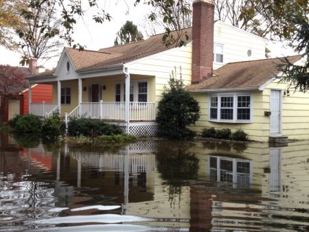
How bad can Hurricane Harvey get? The picture below is of the aftermath of Hurricane Ike after its landfall in an area near where Harvey will come ashore.
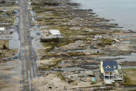
This is what I mean by the headline of this piece. Climate change is relevant to individuals when they encounter evidence of it. For towns along Alaska’s coast that are being inundated by rising sea levels, climate change is very real. For the Maldive Islands and Kiribati climate change is personal.
In yesterday’s New York Times, Jan Urbina wrote an article entitled, “Perils of Climate Change Could Swamp Coastal Real Estate.” The question buyers of coastal properties have probably not asked themselves before now is just how far inland should they be if they plan to buy property in Miami or Virginia Beach or Ocean City or Long Island? What’s the magic number of meters or feet above sea level that will ensure they will still have a vacation home to visit or a permanent residence along a coast? What kind of emergency equipment should they be purchasing along with the house to ensure sustainability?
On HGTV, a popular cable channel that includes programming about finding that ideal shoreline retreat there is never a mention of climate change as part of the selection criteria in determining whether to buy a property or not. Think about what Hurricane Sandy did to homes on the New Jersey seashore. Sandy was called a storm of the century but climatologists are expressing a degree of certainty that storms like Sandy will become more frequent and devastating to coastlines particularly along the American eastern seaboard.
Why is that?
The science of climate change points to several factors:
The limits of the science – tracking detailed data on sea levels is a new science barely 20 years old. The older methods of tracking sea level rise can be found in harbor records such as those kept by cities along the coast. For example New York at The Battery has been tracking mean sea levels since 1850. Data (see graph below) shows an average rise of 2.84 millimeters per year or about 1.1 inches per decade.
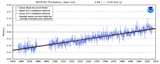
In 160 years that translates to 0.44 meters or 17.6 inches (almost a half yard). That is not a trivial amount. And when you consider the rate of rise in recent years is accelerating what does that mean for the long term equity in purchasing beachfront property in the Hamptons on Long Island? As a home buyer do you want to spend millions on a place that in thirty years may be seriously impacted by rising sea levels or increased frequency of extreme weather events such as a storm equivalent to Sandy? Yet developers can’t help themselves as they continue to build or rebuild as close to the seashore as in the case of New Jersey and Long Island post-Sandy. One would think there would be an awakening to the potential future costs associated with such behaviour.
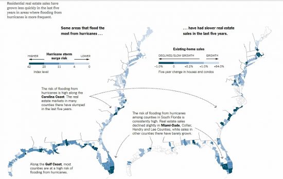
In Urbina’s Times article she notes that maybe the American public is starting to catch on. She writes, “Over the past five years, home sales in flood-prone areas grew about 25 percent less quickly than in counties that do not typically flood, according to county-by-county data from Attom Data Solutions, the parent company of RealtyTrac. Many coastal residents are rethinking their investments and heading for safer ground.” The two maps below illustrate this declining trend over the last five-year period. The map on the left illustrates areas most prone to flooding from storm surges. The map to the right shows the rate of residential real estate sales over the same geography. The alignment of the two in places like the Carolinas and South Florida is unmistakable.
Back in 2014 I wrote about Miami Beach’s ongoing fight against rising sea levels. The neighbour to the larger city of Miami is prone to flooding today. And because the city lacks the ability to raise sufficient taxes other than through property sales, to harden its shoreline it agreed to build 47 new condominiums next to the beach and get the money it needs from these additional buildings which will be under threat from rising seas. As one Florida State University climatologist stated, “When you consider current hurricane threats, and the sea level rise that could erode these properties….Common sense says no, you shouldn’t do it.”
Even Donald Trump has cited climate change in an application to the Irish government for permission to put seawalls along the coast of one of his golf resorts, the Trump International Golf Links & Hotel Ireland, in Country Clare. The application states that the request for permit is required because of “increased erosion due to rising sea levels and extreme weather.” Trump is primarily a real estate developer so even he who denies climate change claiming it is a hoax recognizes the potential peril. And what will be his Southern White House, the property at Mar-a-Lago in Palm Beach, sits right along the South Florida shoreline that is considered at high risk to flooding and storm surges.
Urbina writes that Florida has 6 of the 10 most storm-surge vulnerable urban centres in the United States. She cites a report from a real estate data firm that states current tidal floods amounting to 10 per year are expected to increase to 240 per year by 2045. It is, therefore, no wonder that home sales in Miami-Dade County have dropped 7.6% in the past year compared to a national average increase of 2.6%. The annual cost of flood insurance alone is creating buyer reluctance and as premiums rise to reflect true market risk will be a further inhibitor to prospective buyers. It sort of works like an appreciating carbon tax.
And as states change real estate disclosure requirements purchases of shoreline properties may be seen by potential buyers as even more risky. In California, Washington and Pennsylvania today property sellers and their agents must disclose natural hazard risks. But along the Atlantic seashore there is less honesty in real estate dealings. Only a limited area along the Florida coast requires realtors to disclose risks from nature including flooding and wind. When you think about this in a state that periodically is hit by hurricanes, one would expect full disclosure to be a basic requirement. In tidewater Virginia that is not the case. In North Carolina among the 31 disclosure requirements is one question, “Is the property subject to a flood hazard or is the property located in a federally-designated flood hazard area?” There is no follow up to the question asking about the history of the property related to past flooding. Yet in another question about natural risk disclosure it asks about current and “past infestation of wood destroying insects.” I gather termites and carpenter ants are seen as the greater risk when selling a property.
Urbina quotwes George Kasimos, a New Jersey real estate expert who states, “A homeowner may be approved for a $300,000 mortgage with a $3,000 a year flood insurance premium.” But what if the loan is contingent on a $10,000 flood insurance premium. Kasimos sees rising insurance premiums covering natural risks as the most significant factor in reducing interest in the purchase of coastal properties particularly along the U.S. Atlantic seaboard. You can’t get more personal than the fear that you feel when you might lose a $300,000 investment to a rising Atlantic Ocean caused by warming of the water and the air above it.