In a paper entitled, “Using climate model simulations to assess the current climate risk to maize production,” published in Environmental Research Letters, Volume 12, Number 5, Met Office researchers Chris Kent, Edward Pope, Vikki Thompson, Kirsty Lewis, Adam Scaife and Nick Dunstone describe the results of advanced climate modelling focused on maize, a critical crop for global food security.
Based on observed historical data and present day climate analysis that looks at stresses to maize, the researchers applied 1,400 simulations to attempt to quantify the future risk to the two principal maize growing areas of the planet, the United States and China. What the simulations predicted was a potential “multi-breadbasket failure” from “climate-related maize shocks.” They estimated the likelihood of a double whammy to these important maize growing areas as increasing at a rate of 6% per decade based on future climate models and forecasts.
Chris Kent, the lead author of the study, states in an interview. “This is the first time we have been able to quantify the risk. It hasn’t been observed in the last 30 years, but the indications are that it is possible in the current climate….The impact would be felt at a global scale.”
Maize or corn, the name we give it here in North America, is along with rice, wheat, and soybeans, represent the world’s staple crops feeding most of our global population. The United Nations Food and Agriculture Organization estimates that maize, rice, and wheat make up 51% of all the calories consumed by humans on the planet.
The Met Office risk models looked at world production of maize estimated at 1 billion tons in 2014. Of that total, 360 million tons were produced in the United States, and 215 million in China. Extreme weather events impacting either of these two nations or both within a single growing season would be the feared double whammy.

In 2016, Africa was victimized by a major maize crop failure brought on by a drought that impacted 50 million. It marked the second year of a drought that affected crops in Central and East Africa. Malawi, Mozambique, Lesotho, Zimbabwe, Namibia, Madagascar, Angola, Swaziland, Botswana, Kenya, Somalia, Ethiopia, South Sudan and the Democratic Republic of the Congo were all impacted. Nearly 31 million faced near starvation. Imagine if a similar failure happened in China, the United States or both. Instead of 31 million, the impact would be felt by hundreds of millions.
The Met Office models and data showed that such an occurrence is an increasing risk. States Kirsty Lewis, a co-author of the study and Science Manager at the Met Office, “We have found that we are not as resilient as we thought when it comes to crop growing…..We have to understand the risks we face or there is a real danger we could get caught out.” The Met Office is now working cooperatively with researchers in China to better understand that country’s growing climate risks on agricultural production.

]]>
The study results, published in Environmental Research Letters in the last week, map the velocity of ice movement and discharge in the Queen Elizabeth Islands. The glaciers on these islands cover 105,000 square kilometers (over 40,000 square miles) and represent 25% of Arctic land ice outside Greenland. Eight major icefields cover Ellesmere, Devon, Axel Heiberg, Amund Ringness, Ellef Rignes, Borden, Mackenzie King, Bathurst, Cornwallis, and Prince Patrick Islands.

Observations prior to 2005 show a mass balance between seasons with a small incremental loss of ice annually. But since 2005 the mass loss has increased leading to many islands exhibiting ice-free areas for the first time since observations were recorded. The study looks at both land-terminating and marine-terminating glaciers with a general trend to increased melting for both since 2005. The scientists conclude that 90% of the melt correlates to temperature rises since that year.
Lead author in the study, Romain Millan, an Earth system scientist, states, “We identified meltwater runoff as the major contributor to these ice fields’ mass loss in recent years. With the ongoing, sustained and rapid warming of the high Arctic, the mass loss of the Queen Elizabeth Islands area is likely to continue to increase significantly in coming decades.”
Before 2005 ice loss was attributed as follows: 52% to calving icebergs and 48% to surface melt. But now surface melt represents 90% of the ice loss. If the trend continues, which considering the sea ice loss and overall atmospheric temperature trends in the Arctic, we may see the Queen Elizabeth Island glaciers vanish before century end. And that means a little more gitty up to overall global sea level rise. By how much? The study doesn’t say.

The Solomon Islands in the Pacific Ocean are home to more than 560,000. World War II buffs know these islands from the battle of Guadacanal, a turning point in the American advance against Japan. The islands are a combination of volcanic and reef construction with the latter lying a few meters above sea level. The researchers studied the coastal dynamics of 33 of these reef islands, a small number among the more than 1,000 islands that make up the chain. They did this by reviewing satellite imagery and by relying on local knowledge describing the changing coastline. Their conclusion, rising sea levels have been encroaching on the islands since first recorded observations back in the 1930s.
The majority of Solomon Island human settlements lie along the coastlines within the chain and over the past two decades there has been noticeable changes to sea levels. From 1950 to 1994 the rate of increase was 3 millimeters per year. Since then it has accelerated to 7 to 10 millimeters annually.
The researchers recorded “anecdotal accounts …. of extreme shoreline changes over the past decade…across all provinces of the Solomon Islands.” Their main focus looked at 32 reef islands forming barriers to two larger islands, Isabel and Roviana. These reef islands remain largely uninhabited but are used daily by islanders for fishing and other activities. Five of them on the northern coast of Isabel, however, have completely submerged. Six have declined in area by more than 20% between 1947 and 2014. For Roviana’s barrier islands results were mixed showing six losing surface area while the remaining six actually growing. The images below tell the story.
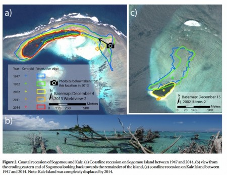
If you can’t read the caption below the image let me explain. The top left satellite image marked a) shows coastal recession on one of the barrier islands from 1947 to 2014. You can see just how much of the island has vanished over that time period. The picture in the bottom frame marked b) is a view of what that island still looked like in 2014. There’s not much there. And the top right image marked c) shows significant reduction from 1947 to 2014 for a second island in the chain. These are just two examples from eleven islands studied in the northern Solomon Islands that have vanished or become severely eroded.
Ascribing what is happening to human influenced global warming alone may not be the entire picture. The Solomon Islands are located at a geological convergence point among the Pacifc, Solomon Arc and Australian Plates. The result, a tectonic hot spot where earthquakes occur fairly frequently. For example in 2007 a megathrust earthquake on the Pacific Ocean floor caused Roviana to lose altitude. Isabel, however, lies in a more benign locale within the chain and has been minimally affected by recent earthquake activity.
The researchers have projected 21st century sea level rises between 20 and 100 centimeters by 2100 based on several climate study models. These projections do not account for the erosion activity brought on by waves and extreme weather events. When added to rising sea levels it is clear that the chain is under unprecedented threat with inundation severity and frequency reaching unacceptable levels already in several communities. One village has seen more than 50% of its houses disappear into the ocean. The capital of one of the islands has actually relocated all its citizens because of the threat of sea level rises.
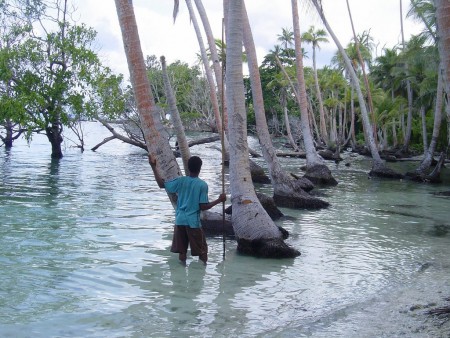
Back in 2013 The Solomon Islands joined other Pacific Ocean nations in signing The Majuro Declaration, a statement that recognized the unique vulnerability Pacific island states faced from anthropogenic climate change. It was a call for help sent out to the rest of the world. These nations led the call for a 1.5 Celsius limit on global warming at the recent COP21 meetings in Paris. That’s because projections at 2.0 Celsius would have unprecedented sea level impacts for these nations. But the conclusions of this latest study indicates that even with concerted effort by all nations to reduce carbon-based energy it will not stem the tide of accelerating sea level rises enough to save many of the islands, and the homes of those who inhabit them.
A recent study published in the April 2012 edition of Environmental Research Letters, the Journal of the British Institute of Physics, and entitled The Long-Term Effect of Increasing the Albedo of Urban Areas, looks at proposals to make cities more sunlight reflective by painting roofs white and using light-coloured materials in paved areas. The authors, Hashem Akbari, H. Damon Matthews and Donny Seto, of Concordia University in Montreal, argue that pavement and roofs represent more than 60% of city surfaces. Dark roofs and asphalt are solar energy traps responsible for much of the heat effect cities experience. Called the heat island effect, cities are much warmer than their surrounding rural settings. This extra heat contributes to increased energy usage for air conditioning. The heat also plays a role in urban smog leading to increases in human respiratory diseases. And finally the heat is the primary cause of weather-related deaths effecting both young and the elderly frail.

The authors argue that reflective surfaces create a high albedo reducing the rate of heat absorption in urban surfaces. If you are not familiar with the term albedo, in scientific terms it is the fraction of light striking a surface that gets reflected from that surface. Objects with high albedo tend to be light. Objects with low albedo tend to be dark. Snow and ice have high albedo. That’s why the presence of snow in winter conditions contributes to further atmospheric cooling. The absence of snow, however, lets the uncovered land surface absorb light, convert it to heat and warm the air above it, a low albedo effect.
To obtain high albedo and reduce the heat island effect in urban areas the authors argue that a simple white coat of paint would provide an immediate cooling effect. They propose as cities renew infrastructure that paved areas use materials that are light-coloured which will increase their reflectivity.
It should be understood that with only 0.05% of the world’s land masses covered by cities a dash of white paint won’t do anything to mediate global atmospheric warming but it sure can help keep your urban neighbourhood a little cooler in the summer.
Solar Energy You Can Paint On Your House
University of Southern California researchers have created a liquid containing solar cells made from nanocrystals. Richard Brutchey and David Webber’s research is featured in Dalton Transactions, an international journal for inorganic chemistry. The solar nanocrystals are four nanometers in size. You can fit 250 billion of them on the head of a pin. In liquid they can be painted or printed on to a surface and represent a much cheaper way to produce solar energy.

The solar nanocrystals are not as efficient in generating electricity as current photovoltaic silicon wafers but their abundance makes up for this. By making the liquid suspension an efficient conductor the nanocrystals can build tiny bridges among them to transmit electricity. The liquid can be painted on almost any surface material and the result solar panel can be shaped to fit anywhere.
The researchers used cadmium, a highly toxic substance, in creating their nanocrystals. They are now looking at less toxic materials to create their solar cell paint, coming soon to a big box hardware store near you.
]]>


