The post Advances in Flight Technology Celebrated 25 Years After 9/11 appeared first on Techso Mogro.
]]>Flying commercial took on a whole new look after that, and this was well before the industry began paying attention to carbon footprints and new design efficiencies.
Aviation has undergone remarkable transformations over the past two decades, driven by innovations in materials science, aerodynamics, fuel alternatives, real-time data collection, environmental concerns and more.
Today’s aircraft bear little resemblance to those of even fifteen years ago, equipped with technologies designed to improve operational safety and efficiency. From cockpit automation to lightweight composite materials and structures, advances in aircraft engineering represent a cumulative effort to push the avionics boundaries.
Understanding these developments provides insight into how modern avionics continues to evolve and what operators and passengers can expect in the years ahead.
Modern aircraft rely on composite materials, providing significant advantages over traditional aluminum airframes. These materials combine carbon or glass fibre with resin matrices, providing greater strength while weighing substantially less than conventional alloys. Integrating these materials is fundamentally changing the industry, beginning with design and manufacturing, and throughout aircraft operational lives.
Composites reduce aircraft weight. One of the aircraft recently entering commercial use is the Boeing 787 Dreamliner, built using approximately 50% composite materials. By weight, composite materials are more expensive than aluminum. The advantages in using the former over the latter, however, are significant, because less weight means less jet fuel consumption. Jet fuel represents between 20 and 30% of airline operating costs in normal periods. Today, with the war in the Persian Gulf, that percentage is creeping upward and could reach 40 to 50%.
Consuming less jet fuel also translates into fewer greenhouse gas (GHG) emissions even though composite material production versus aluminum favours the latter over the former. As engineers continue to develop new composite formulations and manufacturing techniques to make these materials more affordable and easier to produce at scale, aluminum’s carbon footprint advantage should vanish.
Aerodynamic improvements represent a critical focus for manufacturers seeking to enhance fuel efficiency and performance. Computational fluid dynamics software now allows engineers to test thousands of design variations using digital twin technology before having to build physical prototypes. This is significantly accelerating the development cycle.
Winglet designs, sharklet additions, and optimized fuselage shapes are contributing to reduced drag and improving the lift characteristics of traditional wing and tube designs.
Airlines are retrofitting existing aircraft with aerodynamic enhancements such as split-scimitar winglets, reducing fuel consumption by several percent on long-haul flights.
Natural laminar flow is being enhanced by using specially designed surfaces that smooth airflow over wings and fuselage. These aerodynamic refinements are being made to new aircraft as well as being incorporated into existing fleets.
Cockpit technology has advanced dramatically with sophisticated automation systems that enhance safety and reduce pilot workload during complex flight operations.
Modern flight management systems integrate navigation, performance calculations, and autopilot functions into unified digital platforms to provide real-time decision support.
Cockpits replaced mechanical instruments with integrated digital displays several decades ago. Today, they continue to evolve using touchscreen interfaces and synthetic vision capability. System displays provide terrain awareness and warning information, weather radar imagery, and traffic collision avoidance data for pilots to easily interpret even when facing challenging conditions.
Fly-by-wire technology, which replaced mechanical control linkages with systems managed by computers, has proven a safety advantage for multiple aircraft types and as demonstrated over millions of flight hours.
The continuous refinement of digital control systems, combined with robust redundancies and pilot training, has made aviation statistically safer with each technological generation.
The industry is pursuing alternatives to today’s conventional jet fuel and modifying engine technology to burn them.
Why? Climate change is dictating a need for the industry to reduce its carbon footprint.
Alternative fuels being tested and perfected include sources like used cooking oil and agricultural waste. New synthesized fuels are being developed from CCUS (Carbon Capture Utilization and Storage) technology. Electric propulsion is another alternative, as is hybrid-electric propulsion. In the latter category, using compressed or liquid hydrogen supplemented by hydrogen fuel cells is among the candidates to replace conventional jet-fuel-powered aircraft.
Electric and hybrid-electric propulsion systems remain at an early stage, but already converted aircraft and wholly new designs are doing demonstration flights. Among the first was a converted de Havilland DHC-2 Beaver that in 2019 successfully flew a battery-powered version, the eBeaver, on a 70-kilometre (45-mile) point-to-point test flight. Since then, electric-powered aircraft have undergone flight demonstrations, some built by companies like Airbus, Rolls-Royce, Pratt & Whitney Canada, Honeywell, and GE Aerospace.
Burning hydrogen, either using compressed gas or liquid hydrogen, is also in the mix. Hydrogen fuel cells are also being tested. In 2023, H2FLY demonstrated a liquid hydrogen and hydrogen fuel cell-powered aircraft that flew 842 kilometres (over 450 nautical miles).
Before H2FLY got off the ground, Airbus was working with ElringKlinger, a German fuel-cell developer, on a hybrid-powered aircraft using a gas turbine engine and hydrogen fuel cells. The project began in 2021 but was eventually mothballed. Recently, Airbus announced it would begin in 2027 to work on a new hydrogen-powered 40- to 80-seat commercial aircraft powered using a hybrid hydrogen-based technology.
Using alternative fuels presents challenges for the industry that include retrofitting and redesigning engines to burn them. The ideal is not to have to make major design modifications or operational changes to demonstrate feasibility.
Other proposed changes to engine technology have included geared turbofan engines and open rotor designs. Some of these prototypes are demonstrating fuel consumption improvements exceeding 20% over current engines.
Today’s aircraft are supported by some of the most data-rich predictive analytics in modern engineering. Aircraft contain embedded sensors that continuously collect operational data, which is transmitted to ground-based systems for maintenance analysis. This predictive approach allows engineers to spot wear and tear failures days or weeks in advance, preventing costly and dangerous mid-flight incidents. Real-time reporting means proactive maintenance, a fundamental shift from fixed-interval servicing.
Artificial intelligence (AI) in the form of machine learning (ML) algorithms is increasingly being used to analyze patterns in all this data. The more data history, the more accurate the ML algorithms get.
Ground operations use layered positioning and surveillance aided by navigation systems, sensors, vehicle transponders, and other software to create real-time pictures of surface operations. This allows airport teams to reposition aircraft on the tarmac, relying on modern aircraft tugs to move jets safely and efficiently between gates and maintenance bays.
The post Advances in Flight Technology Celebrated 25 Years After 9/11 appeared first on Techso Mogro.
]]>The post The Skies “They Are Achangin” – The Age of Drones is Upon Us appeared first on Techso Mogro.
]]>Drones are everywhere these days. They have become a weapon of choice in two current wars, the battle between Russia and Ukraine and the war being fought on the borders of Israel. Weaponized drones are cheap to build, and can carry armaments or be used as kamikaze. They can be directed by using GPS and other navigation tools. They are relatively cheap to build and can be turned out by the thousands.
Drones can be used for domestic, not just military applications. Their onboard navigational systems make them useful to deliver things. Amazon is experimenting with drone deliveries in select markets these days. As drone numbers grow, managing the traffic they will bring to communities will increasingly present an airspace challenge.
Current air traffic management systems are incapable of monitoring and guiding drones. These legacy systems are designed for piloted aircraft with humans behind the controls. That’s why NAV Canada, a 1996-established non-profit organization that operates Canada’s civil air navigation system, has engaged private partners to help build uncrewed capacity into their existing navigational management systems.
Ryan Coates is the Executive Director of the Remotely Piloted Aircraft Systems (RPAS) Task Force working with Transport Canada and other industry partners to build this traffic management system to incorporate autonomous and remotely controlled drones. Trials are currently underway with NAV Canada which is responsible for air traffic control, aeronautical communication, navigation aids, and aviation weather services covering 12 million aircraft annually flying over 18 million square kilometres (nearly 7 million square miles) of North American and Atlantic airspace.
How do you integrate drones into skies already filled with traffic? Coates, in a December 10, 2024 press release notes that advancements in drone technology are up to the task and changing the definition of aviation. Autonomous and remote-controlled aircraft are being tested for use in real-world applications with an initial focus on healthcare logistics and infrastructure surveillance and maintenance.
Drones can navigate complex airspaces. They can fly at variable altitudes. Their guidance systems can put them right where they need to go. Drones can reach remote communities faster and more effectively than existing fixed-wing and rotor aircraft. They can deliver emergency medical supplies, medications, blood, vaccines, and more during disasters when normal logistics are disrupted. If land routes are blocked, drones can fly over them. If fires limit aircraft visibility, drones with advanced navigation and artificial intelligence (AI) can see through the smoke.
Richard Brown is the COO of Variable Pitch Inc., a Canadian software company developing unmanned aircraft and remotely piloted systems. His company is participating in the NAV Canada trial demonstrating its advanced radar, real-time weather data and AI traffic control systems for navigating in complex aerial environments. The technology offers Beyond Visual Line of Sight (BVLOS) capability meaning the drones can fly without the need for a remote human pilot in constant visual contact. Extended range is made possible by built-in GPS navigation, high-resolution cameras, LIDAR and infrared sensors, and autonomous AI flight software.
The two immediate non-military applications that NAV Canada is testing are healthcare delivery and infrastructure maintenance and inspection. Brown states, “Drones can bridge the gap between urban healthcare centres and remote communities. The potential to deliver life-saving treatments within minutes can dramatically change outcomes in emergencies.”
Then there is the use of drones for the visual inspection of bridges, power lines, railways and other vital infrastructure. Drones can see difficult-to-reach sites that are costly to get and difficult and dangerous for human observers. Their visual sensing technologies can gather real-time data to spot corrosion, cracks, and other material issues that can be overlooked by more conventional inspections. Drones used this way are cost savers. They allow for more frequent inspections so preventive maintenance can be done before damage leads to costly major repairs. To call them an industry game changer is an understatement.
NAV Canada trials may establish the standard for other countries to manage drones within their civil airspaces. Even before the work NAV Canada is currently doing, commercial drone systems are already operational in 2024.
In the medical realm, I have previously written about drones used in trials for medical deliveries in Costa Rica. Meanwhile, in the U.S. there is Zipline, which presently offers prescription, over-the-counter medicines, and medical device delivery to patients’ homes; laboratory sample transportation between health facilities for faster diagnoses; and immediate inventory management provisioning between lab and hospital locations to ensure facilities are fully supplied. The company’s drones are in use at the University of Michigan, the Mayo Clinic and the Cleveland Clinic.
For examples of drones already in use to support infrastructure projects, here are four that I discovered.
Yes indeed, the “times are achangin” and it is the sound of drones, not music, that you are hearing.
The post The Skies “They Are Achangin” – The Age of Drones is Upon Us appeared first on Techso Mogro.
]]>The post Hypersonic Aircraft Planned to Connect Tokyo to Los Angeles in an Hour appeared first on Techso Mogro.
]]>Venus Aerospace claims that no one has built an engine to make one-hour global transport cost-effective. This gave me pause since I have been writing about SpaceX’s plans to offer a suborbital rocket point-to-point travel service for several years since announcing the Starship (formerly the BFR). The differences are interesting. SpaceX wants to use rockets. Venus Aerospace wants to use a spaceplane.
Venus Aerospace is Houston, Texas-based. In the last week, it made headlines revealing it had raised $20 million US in funding for its zero-carbon emission spaceplane featuring next-generation rocket engine technology, an innovative aircraft shape (see image above), and a design that would allow it to takeoff and land using existing airports.
Supersonic refers to being able to travel faster than the speed of sound travelling through the atmosphere at sea level which is 1,235 kilometers (767 miles) per hour in temperature conditions of 20 Celsius (68 Fahrenheit).
The first aircraft to surpass the speed of sound was the rocket plane known as the Bell X-1 which flew in 1946. Since then surpassing the speed of sound, known as Mach 1, has become common for military aircraft, but not commercial airplanes with the exception of the European Concorde.
NASA, currently, is building a supersonic commercial demonstrator aircraft that follows in the footsteps of the Concorde that flew from 1976 to 2003. The Concorde could attain speeds of better than Mach 2 (twice the speed of sound) and carry up to 128 passengers. It was restricted from flying at supersonic speeds when over land because of the sonic boom it created as it passed. I remember being in Reston, Virginia, the first time I witnessed the Concorde as it flew into Washington, DC. Even at subsonic speeds it was a pretty noisy plane.
In reviving the idea of supersonic flight, NASA’s X-59 QueSST is designed with what the Agency calls quiet supersonic technology, which means a much reduced sonic boom. Testing is to begin later this year over select overland routes to gauge consumer acceptance.
Hypersonic is supersonic on steroids. Instead of Mach 2, hypersonic aircraft fly at speeds greater than Mach 5. The U.S. Airforce’s experimental X-15 was the first spaceplane to achieve hypersonic speeds. It flew in the 1960s and was air-launched strapped to a B-52 bomber and used a rocket engine. The Space Shuttle during re-entry achieved hypersonic speeds.
Now Venus Aerospace wants to achieve hypersonic speeds using its unique technological innovations allowing it to fly at speeds of up to Mach 9 (over 11,000 kilometres or more than 6,900 miles per hour) at altitudes exceeding 51 kilometres (over 32 miles). Its hypersonic spaceplane would take off from airports like a conventional jet. But once over water, the rocket would fire taking passengers not quite to the edge of space and not to a level where weightlessness would be experienced.
Venus co-founder and CEO, Sassi Duggleby, stated in a radio interview this week some of the benefits of hypersonic flight. Duggleby served as a systems engineer at Virgin Orbit, Sir Richard Branson’s company.
Besides flying across the Pacific in an hour for a meeting and returning in time for dinner at home, Duggleby points out: “If a factory is down and needs a part, you could literally have it anywhere in the world in an hour…Even global organ transport suddenly opens up to the market.”
When will Duggleby’s hypersonic plane fly? Ten years from now.
In a TED Talk with Gwynne Shotwell, COO and President of SpaceX, in 2018, she told an eager audience that her company plans to offer interplanetary point-to-point rocket travel to anywhere on the planet in 30 minutes. At the time, SpaceX was beginning to develop the Starship. To deal with the noise issue, SpaceX planned to launch its Starships from offshore platforms with a fleet of rapidly reusable rockets capable of moving passengers and freight.
SpaceX has built the Starship not just for sub-orbital use. It is the platform upon which they are building a fleet of orbital and Deep Space vehicles including a lunar lander for the first NASA Artemis return-to-the-moon missions.
It should be noted that Venus Aerospace isn’t the only company seeking to offer hypersonic commercial flight. Hermeus Aerospace, an Atlanta, Georgia-based company has plans to launch its own hypersonic aircraft by 2029. Another company, Florida-based IO Aircraft, features on its website a number of hypersonic models including business and commercial passenger aircraft. And Russia, China and the US Airforce are working on hypersonic scramjets as weapon and reconnaissance systems.
The post Hypersonic Aircraft Planned to Connect Tokyo to Los Angeles in an Hour appeared first on Techso Mogro.
]]>The post Gizmos & Gadgets: American Air Force Seeks Urban Air Taxi Technology from Commercial Partners appeared first on Techso Mogro.
]]>VTOL technology is old news in one respect. After all, we have had helicopters since the original VS-300 took flight in 1939. What’s different, however, is that both the Air Force and the space agency are looking for a hybrid technology that incorporates the fixed-wing and helicopter aircraft characteristics.
At Wright-Patterson Air Force Base, near Dayton, Ohio, the Americans have set up a research and development centre for VTOL technology. They have created this new project and combined it with an older one called Agility Prime to find manned or unmanned aircraft to do the jobs of shuttling small numbers of people or light cargo short distances. The technology may also be used for small-number troop insertions, and search and rescue missions.
Currently, the American Air Force has been using a VTOL but its nothing like what they are seeking. Instead, it is a 26-ton aircraft called the V-22 Osprey. Built by Bell Helicopter and Boeing it has been designed for much larger payload and people deployments. It has had numerous problems throughout development and operation and if it weren’t for the $29.1 billion already expended on it, the Air Force might have considered scrapping it in its entirety. The Osprey has suffered from a number of crashes in which lives were lost, and its per-unit cost of almost $84 million, when compared to Black Hawk helicopters at $20 to $40 million each, has raised many eyebrows.
But the specifications that made the V-22 attractive, maneuverability, speed, and adaptability over fixed-wing and rotor airframes is the reason the Air Force is revisiting the idea of the VTOL but this time with a new twist: developing a light aircraft with a powerplant initially that is hybrid, and later all-electric. The current requested specification from commercial developers also includes a non-electric VTOL, manned or unmanned, with a maximum takeoff weight of no more than 600 kilograms (1,320 pounds).
Often described as a flying car, light VTOLs are already out there in prototypes from various suppliers. Back in 2016, I reported on the Ehang 184, a Chinese-built single-passenger autonomous quadcopter with a top speed of 100 kilometers (60 miles) per hour, and a range distance of 16 kilometers (10 miles). Now add the following to the list which includes American and European designs:
NASA launched a four-year testing program for unmanned VTOLs last summer in an Urban Air Mobility (UAM) Grand Challenge. Developmental testing is planned for the fall of 2020 with those companies that cut the mustard entered into a full Grand Challenge with cash prizes. The Air Force plans to run similar challenges beginning in 2020 but it is unlikely there will be cash awards handed out. The winners will likely, however, win a pretty pricey procurement contract for the eVTOLs, servicing, and maintenance.
The demand for VTOL technology, according to Business Wire, the Berkshire Hathaway Company, is expected to grow to $3.58 billion by 2030 and was worth $498 million USD last year.

The post Gizmos & Gadgets: American Air Force Seeks Urban Air Taxi Technology from Commercial Partners appeared first on Techso Mogro.
]]>The post More Insights into the Future of Disaster Relief appeared first on Techso Mogro.
]]>In the past 50 years, the frequency of natural disasters has increased by 500%. From 2005 to 2014, more than 700,000 people died in natural disasters around the world. Besides their death, the damage inflicted from these events amounted to $1.4 trillion USD.
Among the types of natural disasters recorded were wildfires like the ones that have created a new season called “fire seasons” in countries like Portugal, Spain, Australia, Brazil, and provinces and states such as British Columbia, and California. One might question calling wildfires natural disasters since human behaviour, not just droughts is a strong contributing factor. Nonetheless, the need to develop prevention and rapid response to these events has never been more needed particularly since human population growth has increasingly encroached on the natural world.
I have taken the liberty to edit the raw material Peter has sent but have stayed true to his intent as he describes the development of technologies such as artificial intelligence (AI), robotics, drones, sensors, and smart networks and their application to preventing, predicting, and responding in the first hours to help victims of these events. In this posting he looks at three technology groups specifically. They include:
When it comes to immediate and high-precision emergency response data is gold. We are witnessing the deployment of global space-based telecommunications networks and the rollout of 5G with the potential to connect every individual on this planet. Aside from democratizing the world’s information the upsurge in connectivity will soon grant anyone the ability to broadcast geotagged data, particularly useful in the face of a natural disaster. This is crowdsourcing that can play a vital role in emergency response, turning historically one-way blind rescue operations into a two-way dialogue between connected crowds and smart response systems.
With this skyrocketing abundance of data comes a new paradigm, one in which we no longer face a paucity of answers. Instead, it will be the quality of our questions that matter. And this is where AI comes in. What if we could map all incoming data points, or predict the dynamics of a flood, identify a tsunami’s most vulnerable targets, or plot the path of a storm? Through the power of volunteer crowdsourcing we can create relatime information updates to help optimize crisis response.
Born out of Stanford University under the mentorship of leading AI expert Andrew Ng, One Concern is a using AI machine learning to predict and quantify the impact of natural disasters, and to build more resilient businesses, infrastructure, and global communities. Partnering with the City of Los Angeles, San Francisco, and numerous places in San Mateo County, One Concern assigns verified, unique digital fingerprints to every location. It builds robust models of each system and then monitors site-specific impacts from climate change, seismic movements, and other natural disasters. It combines this data with legacy-created data about city infrastructure and former disasters, and then uses all of it to predict future damage under a range of disaster scenarios along with advice on prevention and mitigation. In its four years of existence, One Concern can now use its AI to make precise predictions with 85% accuracy in less than 15 minutes.
Adam Kochanski and a team of researchers at Utah University are developing an AI forest fire mapping algorithm built using historic and new data to predict how fires spread and what weather events follow in their wake. The team has used predictive forest fires (set deliberately for the purpose of spurring forest regrowth) accompanied by infrared-camera-fitted drones, laser scanners, and sensors to collect data to build a predictive model. The experiment is contributing to “coupled fire-atmosphere models,” which leverage collected data to predict how wildfires influence local weather conditions and the interaction that occurs between the fires and spawned weather. Kochanski’s model is proving to be remarkably accurate in predicting wildfire behavior. It is hoped that the tool will help to stem early fires before they gain momentum, saving forests, lives, property, and entire ecosystems.
The spatial web isn’t limited to a set of wired access points and wireless hotspots. The spatial web acts as a mesh network connecting entire cities using hundreds of dispersed nodes that communicate with each other and share a network connection non-hierarchically. This puts the power of networking and crowdsourcing intelligence into the hands of every smartphone user.
How can this be used?
Imagine a scenario in which armed attacks break out suddenly across different parts of a city. Clusters of eyewitnesses and at-risk civilians can broadcast an aggregate of 360-degree videos, all fed to a photogrammetry AI that builds a live hologram of the ongoing events to give first responders and those potentially affected a complete visual map.
A coastal community in the throes of torrential rainfall leading to flooding and failed infrastructure can have eyewitnesses collecting live feeds that can be combined with existing maps and data to provide first responders with accurate reporting to specify where relief is needed first. Drones tied into the crowdsourced intelligence could be directed to provide live video feeds, while swarms of drones and robots could gather emergency supplies, and deliver them to where they are needed. This scenario leads us to our next subject.
As hardware advancements converge with exploding AI capabilities, disaster relief robots are graduating from assistance roles to fully autonomous responders at a breakneck pace. Born out of MIT’s Biomimetic Robotics Lab, the Cheetah III is but one of many robots that could form a first line of defense in everything from earthquake search-and-rescue missions to high-risk operations in radiation zones. The Cheetah III can run at a speed of 6.4 meters per second
Now capable of running at 6.4 meters (21 feet) per second, and leap heights of 60 centimeters (approximately 2 feet), doing obstacle avoidance autonomously.

Initially designed to perform spectral inspection tasks in hazardous settings such as nuclear powerplants or chemical factories, the Cheetah III’s various iterations focus on increasing payload capacity, extending range of motion, and even adding an arm for dexterity. As explained by Associate Professor Sangbae Kim, of MIT, the Cheetah III, and future versions is and will be aimed at saving lives in almost any environment. Kim says, “Let’s say there’s a fire or high radiation, [whereby] nobody can even get in. [It’s in these circumstances that] we’re going to send a robot [to] check if people are inside. [And even] before doing all that, the short-term goal will be sending [the] robot where we don’t want to send humans at all, […] for example, toxic areas or [those with] mild radiation.”
Cheetah III is not alone. In February this year, Tokyo’s Electric Power Company (TEPCO) put a robot to the test in the Fukushima nuclear power plant that was heavily damaged in the 2011 tsunami. The robot was able to enter the reactor to retrieve chunks of radioactive fuel at five of six test sites, offering promise for long-term planning to clean up the still-deadly interior.
And Japan’s Mitsubishi Heavy Industries (MHi) is using robots to fight fires autonomously. The MHi Water Cannon Bot can put out blazes in difficult-to-access or highly dangerous fire sites delivering foam or water at 4,000 liters per minute and 1 megapascal (MPa) of pressure. The Cannon Bot and its accompanying Hose Extension Bot form part of a greater AI-geared system. As wildfires grow more untamable, using bots like these could prove a lifesaver. Paired with the predictive AI forest fire mapping described earlier, and delivered to fire sites by autonomous vehicles, solutions like the Cannon Bot means pre-emptive measures will limit fire outbreaks and fewer human firefighters can focus on search and resuce while robots like the Cannon Bot can handle the flames.
And then there is the robot that can build emergency shelters as needed during times of natural disasters. The Hadrian X, from Fastbrick Robotics, can build a fully livable, 180-square meter home in less than three days all on its own using 3D modeling, a robot arm, and a supply of bricks.
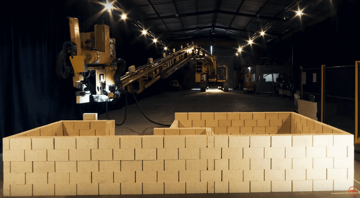
Imagine deploying the Hadrian X and similar autonomous solutions in post-disaster and conflict sites to help with recovery.
But in the absence of bricks a new 3D printing robot called Pylos, developed at the Institute of Advanced Architecture of Catalonia (IAAC), converts almost any soil into building material with three times the tensile strength of industrial clay. Offering myriad benefits, including natural insulation, low greenhouse gas emissions (GHGs), fire protection, air circulation, and thermal mediation, Pylos can build a house on-site for material costs of as little as $1,000 USD.
Next-Generation Relief and Supply Drones (UAVs)
Autonomous drone technology is fundamentally revolutionizing the way we find survivors in need and automate relief supplies. Using high-resolution imagery for real-time mapping and damage assessment, UAVs can far outpace any ground-based rescue team in locating isolated survivors. Drones in China are even being used to build a temporary mobile wireless broadband network in the event of a disaster with the drones acting as cell towers.
Drones have helped assess flood damage in the aftermath of Hurricane Harvey. Texas A&M during Harvey flew 119 drone missions over the City of Houston using them to monitor levee infrastructure and to identify those in need of rescue.
But beyond surveillance, UAVs have begun to provide lifesaving supplies across some of the most remote regions of the globe. Take for example Zipline which has been used in places like Costa Rica, Rwanda, and Tanzania to deliver medical supplies from vaccines to HIV medications, to blood and intravenous tubes. Zipline has proven it can outpace ground-based supply transport to provide critical supplies in less than an hour.
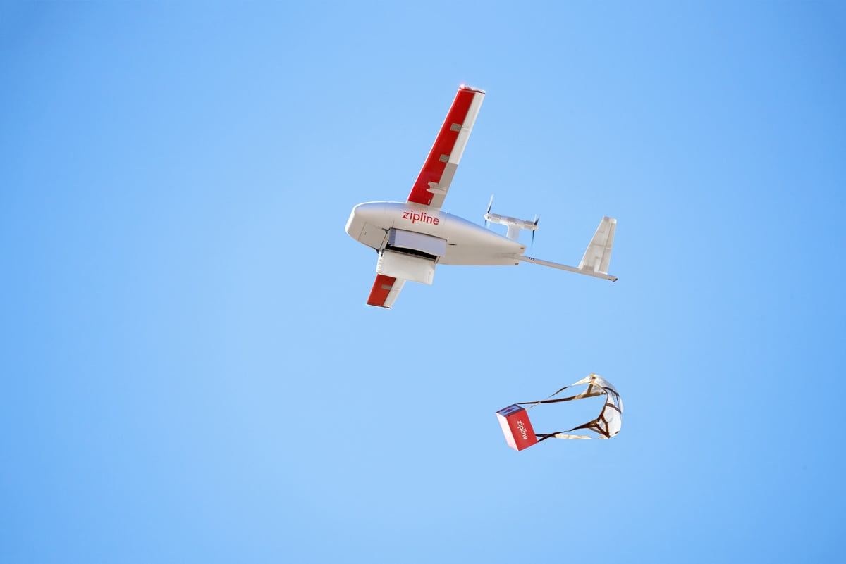
There are even drones capable of delivering much larger payloads. Under contract with DARPA and the U.S. Marine Corps, Logistic Gliders, is building autonomous drones capable of carrying payloads of up to 816 kilograms (1,800 pounds) over long distances. The gliders are built out of plywood and cost a few hundred dollars to produce making them perfect candidates for high-volume, remote aid delivery. They can be navigated by remote control using a human pilot, or fly on their own based on disaster zone mapping data.
One of the most consequential and impactful applications of the converging technologies described above is their ability to transform disaster relief methods. AI-driven intelligence platforms, crowdsourced firsthand experiential data, mobile connectivity, and drone-supplied networks are granting newfound narrative power to those most in need. And as new hardware advancements give rise to robotic responders, swarm technology and aerial drones, we are fast approaching an age of instantaneous and efficiently distributed responses in conflict zones and in the aftermath of natural catastrophes.
The post More Insights into the Future of Disaster Relief appeared first on Techso Mogro.
]]>The post Is Hydrogen the Answer to Making Air Travel Zero-Emission? appeared first on Techso Mogro.
]]>ZeroAvia is not actually planning to build an airplane. Instead, it is making its powertrain available to aircraft manufacturers who already have the customers for the targeted market segment. The current powertrain can handle aircraft with seating between 10 and 20. Along with the powertrain, ZeroAvia will provide the infrastructure and maintenance to operate aircraft using its hydrogen-propulsion technology.
Founder and CEO, Val Miftakhov, is getting the hydrogen fuel used from local renewable energy sources. He estimates that operating costs for air transportation companies who adopt his powertrain will be half that of conventional turbine-powered aircraft, a compelling reason for the industry to adopt the technology.
Miftakhov, who emigrated from Russia to the United States in 1997, and has a doctorate in physics from Princeton University, sees hydrogen as a fuel alternative for the entire transportation sector because it is second to power-generation as the source of carbon dioxide (CO2) which is seen as the greatest contributor to atmospheric warming and our changing global climate. And the industry today produces 12% of the world’s total transportation emissions of which much gets released at high altitude where it accelerates feedback that negatively impacts our atmosphere.
In choosing hydrogen fuel cells, ZeroAvia argues that the energy density of the technology is four-times better than the most advanced battery packs on the market today. And unlike batteries which over time lose their charge capacity, a hydrogen fuel cell does not need to be replaced adding to operating costs and recycling and disposing of what is often polluting materials.
Poking under the hood, ZeroAvia uses renewable-energy sourced liquid hydrogen stored in carbon fiber cylinders to provide the fuel cells with their power. It generates an electrical output of 700 to 800 watt-hours per kilogram, four times the power of the best batteries by weight on the market today.
For those who see hydrogen as a volatile fuel source (remember the Hindenburg), the powertrain design and storage tank positioning within the air frame have met the FAA’s first-stage safety and experimental flight certification. And as of mid-August, the Piper M has undergone 10 test flights according to an article in Forbes, to confirm range, power, and the safety of the technology in normal operations.
Let’s hope the degree of rigour applied to approving the technology for widespread commercial use proves to be far better than the FAA level of inspection in the certification process that green-lighted Boeing’s 737 Max 8.
ZeroAvia sees the powertrain as not limited to commercial fixed-wing aircraft describing it is adaptable for use in rotor craft such as helicopters. When it gets the green light from the FAA it plans to start leasing the technology to manufacturers and operators in 2022, providing the fuel and maintenance as well in a power-by-the-hour business model, one that is increasingly being accepted by the industry.

The post Is Hydrogen the Answer to Making Air Travel Zero-Emission? appeared first on Techso Mogro.
]]>The post Geoengineering: A Tool To Use After a Stain Has Set – Part 1 appeared first on Techso Mogro.
]]>As we see evidence of many of these predictions coming to pass, it is as if we have been spilling stuff on the carpet and leaving it until the stain sets in. When it comes to carpets, tackling stains like this can be next to impossible. And that’s what geoengineering is as a solution to anthropogenic climate change. It is a next to impossible solution with likely many unintended consequences.
Geoengineering is jargon for developing technical fixes to our planet’s climate. The idea is to use a bunch of different technologies to cool the planet down as opposed to addressing the source of what is causing it to warm – excess amounts of heat-generating carbon in the atmosphere.
Among the many geoengineering solutions are:
Academic researchers have been looking at the technical challenges and potential implications of these various schemes. The UK’s University of Cambridge has even established a centre for climate repair. Harvard University has a solar engineering research program. Even the Intergovernmental Panel on Climate Change, the IPCC, has succumbed to the notion that we may have to implement some, if not all of these technical fixes if we are to bend the carbon curve downward and keep mean atmospheric temperatures from rising well above the end of century desired target of no more than a 1.5 Celsius (2.4 Fahrenheit) increase. As a point of reference, since the desired target was set at the Paris Climate Conference in 2015, the world has awakened to realize we are already two-thirds the way there to that limit with more than 80 years remaining in the century. That may explain why the IPCC is exhibiting a bit of desperation in discussing geoengineering as a fix.
Let’s briefly look at each of these technological fixes as we understand them today.
This is the most favoured technical solution to our rapidly warming planet. Why? I don’t know.
What’s involved? Reflecting the sunlight that normally would enter the atmosphere back into space.
One scheme would put large-mirror satellites in high orbit to act as sunshades deflecting the solar radiation from the atmosphere.
The idea overlooks the problem should one of these enormous sunshades fail after a number of years. Not only will it create a space junk disposal problem, but it might de-orbit and crash into the atmosphere. And building and launching a replacement will come at enormous cost both in time and materials.
Do the satellites have to be huge sunshades, or could we park thousands of smaller solar deflectors in low-Earth orbit to reduce sunlight entering the atmosphere, similar to the Elon Musk satellite Internet deployment currently underway by SpaceX?
Astronomers will certainly object to either scheme (they are already to SpaceX Internet scheme) since it would alter the night sky and celestial observations from Earth.
And should a satellite or a number of them fail, how much would that impact atmospheric temperatures in a short period of time, as well as weather patterns?

The more talked about scheme is upper atmosphere aerosol release, also known as stratospheric aerosol injection.
What is involved? The dumping of sulfur particles in the high atmosphere.
Like a volcanic eruption, the particles injected at these elevations, mostly sulfur dioxide (SO2) would remain airborne for years reducing the amount of solar energy reaching the low atmosphere.
The common example seen in reference material is the Mount Pinatubo eruption of 1991 which put a cloud of volcanic ash into the high atmosphere and resulted in a period of global atmospheric cooling that lasted over two years.
For geoengineers to duplicate Mount Pinatubo indefinitely, they could construct a fleet of aircraft and fly them into the lower stratosphere to continuously release SO2. Pinatubo injected about 17 megatons (17 million tons) of aerosols into the upper atmosphere producing a cloud that spread in three weeks around the Earth and eventually covered the entire globe one year after the eruption.
One estimate concludes it would take 1oo specially-designed aircraft, and 4,000 flights beginning annually in the early 2020s, growing by an additional 4,000 flights incrementally until mid-century to halve the radiative impact of the sun on our atmosphere.
The initial cost would be $2.5 billion USD to build the aircraft, and $2.5 billion in operational costs in the first year. Those operational costs would increase as flight frequency grew over the next thirty years.
The challenge of this strategy is little science and research to date has been done on how such a geoengineering project might alter wind, cloud formation, precipitation patterns, ocean surface temperatures and circulation, and continental and sea ice formation and melting cycles.

In Part 2 we will continue to look at proposed geoengineering solutions and their potential to help in mitigating climate change.
The post Geoengineering: A Tool To Use After a Stain Has Set – Part 1 appeared first on Techso Mogro.
]]>The post At the Paris Air Show Climate Change Action Creates a Call for Aircraft Not Powered by Fossil Fuels appeared first on Techso Mogro.
]]>The aviation industry has been described as laggards when it comes to developing alternative power sources for its jet and turboprop fleets. But it is already in the process of developing electric-powered, and hybrid aircraft designed to provide short-distance service of 1,600 kilometers (1,000 miles) or less. This type of distance is, unfortunately, much more costly to fly than transcontinental and transocean flights. How much more so? By a 3X to 5X factor. But in terms of practicality based on the limits of power from batteries, that appears to be the electric aircraft sweet spot. And then there are the power-to-weight ratio requirements for airplanes during takeoff and at various moments during a flight that, at the moment don’t square with the energy derived from current battery technology.
So with all these constraints, it shouldn’t be a surprise that the two largest aircraft manufacturers in the world, Boeing and Airbus, are both tinkering with prototypes. At the Paris Air Show, Airbus General Manager in charge of electrification, Glenn Llwewllyn describes why the company is looking at electric power describing carbon dioxide emission reductions as the primary motive. The company has two projects underway working with Rolls Royce and Siemens on both pure electric and hybrid-electric airplanes, the latter which it hopes to test fly by 2021. Boeing has been working with Zunum Aero, with hopes to have its 12-passenger hybrid-electric jet flying by 2022. Other Boeing projects are looking at electric-powered vertical-takeoff-and-landing (VTOL) projects such as the Nexus, more akin to a helicopter than a commercial aircraft.
How close, then are we to seeing electric-powered commercial flight? Airbus estimates at least ten more years before electric flight will be an offering in airline operations around the globe. But at present rates of development from the Big Two, it more than likely will be 20 years before we see electric and hybrid-powered airplanes flying regularly in and out of airports.
If Airbus and Boeing aren’t the players to bring electric and hybrid-powered aircraft to the market, then who is?
Currently, there are 57 other companies, universities and agencies trying to make electric and hybrid-powered flight a reality. But most of these projects aimed at short commuter operations, and some even looking more like flying cars than airplanes.
Despite the current reality, when faced with concerns about climate change tipping points in the near future, reporters and the public are asking why progress on non-fossil-fuel powered aircraft is not proceeding at a faster rate. The threat of a warming planet has taken on some urgency of late with CO2 and methane levels accelerating. States Andrew Murphy, Aviation Manager at Transport & Environment, a European Union (EU) organization set up to monitor environmental progress in transportation, “We have a pretty small timeframe to cut emissions … Either you don’t fly or you replace the fuel with something less carbon-intensive.” The EU’s Aviation Safety Agency has indicated its intentions to label aircraft by carbon contribution. And Sweden and Norway have both committed to short-haul flights to be exclusively powered by electric airplanes in 2040.
Some engineers argue that aircraft could better contribute to lowering GHG levels through the perfecting of fossil-fuel powered jet flight by dramatically improving efficiencies. Today’s jets, although far more efficient than the original Boeing 707s of the 1960s, remain inefficient in terms of performance versus amount of fuel burned.
This is where a hybrid-electric powered aircraft could prove to be a short to mid-term answer. With a hybrid drivetrain, the fossil-fuel powered jet engine could overcome the power-to-weight ratio issue on takeoff and during ascent, with the aircraft switching to pure electric power at cruise elevation.
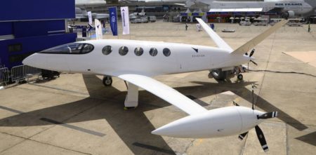
At the Paris Air Show, an Israeli company, Eviation, is showing an all-electric prototype called Alice. A nine-passenger commuter aircraft, Alice runs solely on electric power using motors developed by Siemens.
And then there is NASA whose scientists and engineers are developing hybrid gas-electric propulsion systems that could power an existing Boeing 737, and the X-57, an all-electric aircraft. In NASA’s planning, it sees the year 2035 and beyond as when sustainable alternatives to fossil-fuel powered aircraft will become mainstream.
The post At the Paris Air Show Climate Change Action Creates a Call for Aircraft Not Powered by Fossil Fuels appeared first on Techso Mogro.
]]>The post Will Your Next Amazon Delivery Come By Drone? appeared first on Techso Mogro.
]]>As drone technology becomes more and more sophisticated, many businesses and organisations are exploring how to take advantage of this technology to optimize logistics operations. So, can we expect to see drones flying through the urban skies with packages for delivery slung underneath in the near future or is this just pie in the sky? The infographic below from 2Flow provides an in-depth exploration of the current state and trends around delivery drones both as a technology and service.
It’s evident that an increasing number of businesses are waking up to the enormous potential of drone delivery. In the US alone, drone delivery has surged from a $40 million industry in 2012 to $1 billion in 2017. In fact, a McKinsey report projects that in future up to 80% of all items will be delivered by autonomous vehicles and drones. NASA has produced similar estimates with predictions of 7 million drones in the sky by 2020 with 2.6 million of them commercially operated.
Advocates for cargo drones argue that deployment of this technology will lead to major improvements in delivery logistics, resulting in more efficient and cost-effective operations. For customers, this would mean faster delivery times and lower shipping costs. Some operators envisage drones being used alongside traditional road haulage deployed to cover the last mile for each delivery, and thereby slashing travel time and costs.
A number of key issues, however, remain to be addressed before we see drone delivery technology becoming commonplace. Most critical is the strict government regulation that restricts accessible air space for drones in most countries around the world. What’s more, there are also noise and pollution considerations that will need to be resolved.
Enjoy the infographic that follows. It should answer many of your questions about this nascent technology, and how it may play a growing role in service delivery and the transportation sector.

The post Will Your Next Amazon Delivery Come By Drone? appeared first on Techso Mogro.
]]>The post AI is About to Change the Way We Respond to Disasters appeared first on Techso Mogro.
]]>Diamandis selects three technologies that he believes will have the greatest impact on dealing with the aftermath of or the prevention of disasters. These include:
When it comes to immediate and high-precision emergency response, data is gold. The meteoric rise of space-based networks, stratosphere-hovering balloons, and 5G telecommunications infrastructure is connecting every last individual on our planet. Aside from democratizing the world’s information, this upsurge in connectivity is granting all of us the ability to broadcast detailed geo-tagged data, which is particularly valuable in the face of natural disasters. Armed with the power of data broadcasting and crowdsourcing, disaster victims can now play an important role in emergency response, turning one-way blind rescue operations into a two-way dialogue, connecting the crowd to smart response systems. With the skyrocketing abundance of collected data comes a new paradigm, one in which we no longer have few answers, but rather now can ask the questions needed to ensure we can address the disaster in near real-time.
In the case of emergency response, we can strategically map an almost endless amount of incoming data points. We can begin to predict the dynamics of a flood and identify a tsunami’s most vulnerable targets even before it strikes. And we can trigger automatic aid using surveillance drones which can immediately alert volunteers to take action. Already, a number of organizations are leveraging AI, crowdsourced intelligence, and cutting edge visualization to improve crisis response and speed up relief efforts.
One of these is One Concern. Conceived by victim survivors of past catastrophes and geologists studying volcanoes, this organization leverages AI through analytical disaster assessment to calculate damage estimates. So far One Concern is partnering with a number of California cities including Los Angeles and San Francisco to create unique ‘digital fingerprints’ for every element in an urban area. Their AI platform creates robust models which then help to monitor site-specific impacts from climate change, earthquakes, and other natural disaster events. The collected data when combined with information from these cities including their histories of previous disasters, is then used to predict future damage providing recommendations on structural improvements for prevention and mitigation. Since its inception four years ago One Concern has grown in its ability to make predictions with 85% accuracy in under 15 minutes.
Besides handling natural disasters, there are other uses for crowdsourced intelligence for mapping potential crises. The story of Ushahidi is a case in point.
Ushahidi is the Swahili word for “testimony.” The technology came from a local blogger’s idea to collect reports of violence in Kenya in the 2008 post-election period and map their locations. He sent out a request to techies to create a mashup of where violent and destructive episodes were being reported. Within days, four techies built a platform to crowdsource first-hand reports through short message services (SMS), collecting over 40,000 verified reports and sending back alerts to locals on the ground and viewers around the world.
Ushahidi today is being used in more than 150 countries, with over 100,000 deployments impacting 20 million people. Its open-source crisis-mapping software is accessible to anyone, mining millions of tweets, hundreds of thousands of news articles, and geo-tagged, time-stamped data from countless sources all posted to the Cloud.
Aggregating one of the longest-running crisis maps to date, Ushahidi’s Syria Tracker has proved invaluable in crowdsourcing witness reports, providing real-time geographic visualizations of all verified data, and enabling civilians to report missing people, civilian casualties, disease outbreaks, and relief supply needs all while avoiding the government-controlled cellular network.
As mobile connectivity and abundant sensors converge with AI-mined crowd intelligence, real-time awareness will only multiply in speed and scale. Within the next 10 years, spatial web technology may even let us tap into mesh networks. While traditional networks rely on wired access points and wireless hotspots, the spatial web connects entire cities using hundreds of dispersed nodes that communicate with each other and share network connections non-hierarchically, which means that individual mobile users can establish a local mesh network together using nothing but the computing power of their handheld devices.
If taken further, a local population of strangers can collectively broadcast countless 360-degree feeds across a mesh network. So imagine a scenario in which armed attacks break out across disjointed urban districts. Eye-witnesses and at-risk civilians will be able to broadcast an aggregate of 360-degree videos, all fed through photogrammetric AIs that will build a live hologram in real time to create complete information for first responders. The technology could help a community facing failing infrastructure from a hurricane’s landfall providing a collective live feed of verifiable data in real-time to inform first responders about specific relief needs.
With all the right technology pieces in place, first responders will be able to use drones for automated deliveries. Imagine crowdsourced intelligence, cross-referenced with sensor data and verified algorithmically, along with AI to determine the specific needs and degree of urgency with precision coordinates. Within minutes swarm robots can rush to collect requisite supplies, equip size-appropriate drones and provide rapid-fire delivery.
But wait, there are other breakthroughs on the horizon with AI-geared robots paving the way in emergency response for some of today’s most dangerous environments. These include autonomous robots and swarm solutions.
As hardware advancements converge with AI we will see the emergence of fully autonomous disaster relief robotic responders. A prototype is the Cheetah III, a product of MIT’s Biomimetic Robotics Lab. Cheetah III is capable of running at a 6.4 meters (21 feet) per second pace, can leap heights of 60 centimeters (almost 2 feet), and has sophisticated collision and obstacle avoidance capability. Robots like this may form the first line of defense in disaster responses to earthquakes for search-and-rescue missions, or for surveillance in high-risk radiation zones. Future plans for the robot include payload carrying capability, enhanced range of motion, and increased dexterity. Stated Biomimetic Robotics Lab Director, Associate Professor Sangbae Kim, “the short-term goal will be sending the robot where we don’t want to send humans at all.”

Joining the Cheetah III are a number of other robots designed for working in hazardous zones. In February Japan’s Tokyo Electric Power Company inserted a robot into the damaged Fukushima Nuclear Reactor to retrieve a number of samples of radioactive fuel for analysis and cleanup planning on the site. This robot was guided by human operators and was able to operate in an environment where no one could safely go.
Also in Japan, Mitsubishi Heavy Industries (MHi) has built a firefighting robot called the Water Cannon Bot designed to put out fires at sites considered too dangerous for human entry. It can deliver foam or water at a rate of 4,000 liters (over a 1,000 gallons) per minute and at pressures of 1 Megapascal (145 PSI). The robot can be accompanied by a companion Hose Extension Bot extending the firefighting range by 300 meters (almost 1,000 feet). Imagine using this kind of robot to fight wildfires when combined with predictive AI forest fire mapping and autonomous hauling vehicles, and you have a solution for what is becoming a growing problem as climate change dries out many forest areas. Deployment in anticipation of wildfire would mean the avoidance of population displacement, unnecessary deaths, and significant damage to natural environments.

There are RoboBees developed at the Wyss Institute, Harvard University. These autonomous flying micro-robots have the potential to be used for crop pollination, search and rescue missions, surveillance, and high-resolution weather, climate, and environmental monitoring. They feature self-directed flight and swarm behaviour, that is the RoboBees can work together as a single unit for co-ordinated surveillance operations.

There is Snakebot, developed at Carnegie Mellon University, and designed to navigate in environments completely inaccessible to human responders. Driven by AI, a Snakebot can maneuver through densely packed rubble to find survivors and has onboard cameras and microphones to aid in communication.

Advancements in drone technology will revolutionize disaster response whether to natural phenomena or wars. Drones provide high-resolution imagery for real-time mapping and damage assessment and are already outperforming ground-based rescue teams in locating isolated survivors of a catastrophe. In the aftermath of Hurricane Harvey, a team led by Texas A&M Computer Science Robin Murphy flew 119 drone missions over Houston, to monitor levee infrastructure and identify people left behind by rescue teams.
But drones are capable of much more than surveillance. At the University of Science and Technology of China, engineers have built a first responder temporary mobile wireless broadband network facilitated by airborne drones. And drones are being used to supply remote areas of the planet with lifesaving medicines. One of these is Zipline, a drone delivery system operating in Rwanda and Tanzania that is delivering vaccines, HIV medications, blood products, and intravenous supplies to 11 million living in remote locations. Zipline, a California-based company, has far outpaced any ground-based supply transport, in many instances providing lifesaving biomedical products in under an hour.

Larger capacity aerial drones are being developed for the U.S. Military. Logistic Gliders is using plywood-constructed gliders costing only a few hundred dollars to provide the U.S. Marine Corps with aerial resupply capacity at 816 kilograms (1,800 pounds) per flight. Flying at speeds of up to 250 kilometers (135 nautical miles) per hour, and a 140 kilometer (80 miles) range, these drones can be released from an aircraft or helicopter and are disposable. They can operate autonomously or be guided remotely.

Perhaps one of the most consequential and impactful applications of converging technologies is their transformation of disaster relief methods. While AI-driven intelligence platforms can crowdsource firsthand experiential data from those on the ground, mobile connectivity and drone-supplied networks are granting newfound narrative power to those placed in need because of natural or human-caused disasters. It is this rise of robotic responders, swarm technology and aerial drones that are giving us unprecedented response capacity to catastrophes. Empowered by these new tools, how much can we improve humanity’s overall plight when everyone has similar access to relief supplies and immediate resources in times of disaster?
The post AI is About to Change the Way We Respond to Disasters appeared first on Techso Mogro.
]]>